1980s Maps of Jasper County, South Carolina
Explore 14 historic maps of Jasper County from the 1980s. These maps offer a rare glimpse into what life looked like during the 1980s — showing old roads, neighborhoods, homes, and landmarks that have changed or disappeared over time.
Whether you're researching your family's past, planning a metal detecting trip, or studying how Jasper County's landscape evolved across the 1980s, these high-resolution maps are a powerful tool for exploring the history of this region.
- Focus on a specific era: All maps on this page are from the 1980s, giving you a focused view of this time period.
- See what’s changed: Compare century-old streets, trails, and buildings to today's modern landscape using overlays and satellite layers.
- Research with precision: Use these maps for genealogy, historical research, land use analysis, or educational projects.
- View, download, or print: Maps are fully viewable online in high resolution, and can be downloaded or printed for your own records.
Start exploring Jasper County's history through authentic maps from the 1980s. This is your window into the past.
Jasper County, SC maps
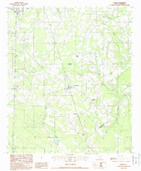
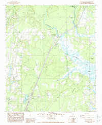
(14)- 1980 Map of Limehouse
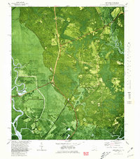 1980 Limehouse1980 Print · USGSJasper County tidelands and the edges of the Savannah riverfront appear here in the early eighties. Genealogists can trace local roots through sites like Chisolm Cem, Jonesville Ch, and the landings at Cook Landing.2 unique versions available
 - 1980 Map of Port Wentworth
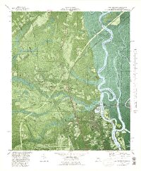 1980 Port Wentworth1980 Print · USGSCoastal Georgia in the late seventies is captured here at the intersection of heavy industry and wilderness. Trace the rail lines of the Central of Georgia or find family landmarks like Mt Marriah Ch and Cherokee Hill Cem.2 unique versions available
 - 1981 Map of Savannah, 1982 Print
 1981 Savannah1982 Print · USGSCoastal Georgia and the South Carolina borderlands are captured here in the early eighties, showing the region's complex network of riverine islands and military installations. Researchers can trace the rail lines of the Central of Georgia and explore sites like Fort Stewart Military Reservation and Garden City.
 - 1981 Map of Sylvania, 1982 Print
 1981 Sylvania1982 Print · USGSThe Georgia and South Carolina borderlands appear in the early 1980s, centered on the river-fed swamps and railroad towns between Sylvania and Estill. Trace family roots and vanished infrastructure along the Central of Georgia line or near Magnolia Springs State Park.
 - 1986 Map of Walterboro
 1986 Walterboro1986 Print · USGSThe South Carolina Lowcountry in the mid-eighties remains a world of expansive wetlands and historic river crossings. Genealogists and historians can trace the rural communities and landmarks of Colleton and Charleston counties, from the Baptist Church at Adams Run to the coastal reaches of Edisto Beach State Park.
 - 1988 Map of Hampton
 1988 Hampton1988 Print · USGSHampton County in the late 1980s reveals a classic Lowcountry landscape defined by the winding Coosawhatchie River and its many branches. Researchers can trace the development of Hampton and Varnville or locate family landmarks near Lowndes Lake and Almeda.
 - 1988 Map of Furman
 1988 Furman1988 Print · USGSHampton County's rural crossroads and rail history are preserved in this late-century survey. Genealogists and historians can trace old family settlements at Stokes and De Loach, or follow the path of the Old Railroad Grade past Furman.
 - 1988 Map of Sheldon
 1988 Sheldon1988 Print · USGSThe Beaufort and Jasper County border in the late eighties is a mosaic of tidal rivers and historic necks. Genealogists and historians can trace the intricate shorelines of Scotts Neck and Seabrook Island, or locate inland points like Sheldon and Gardens Corner.
 - 1988 Map of Calfpen Bay
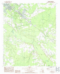
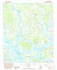
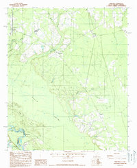
 1988 Calfpen Bay1988 Print · USGSJasper County in the late 1980s reveals a complex landscape of lowland bays and managed wetlands. Genealogists and local historians can locate the historic community of Gillisonville, a rural Cem, and landmarks like the Lookout Tower amidst the Great Swamp.
 - 1988 Map of Yemassee
 1988 Yemassee1988 Print · USGSThe Lowcountry landscape of the late twentieth century is defined by the rail junction at Yemassee and the winding Combahee River. Genealogists and historians can trace the footprint of rural communities like Pocotaligo, Salkehatchie, and Blountville.
 - 1988 Map of Coosawhatchie
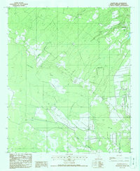
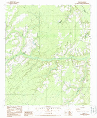
 1988 Coosawhatchie1988 Print · USGSJasper County's river-threaded Lowcountry is captured here in the late 1980s, where the landscape is shaped by coastal necks and river bends. Genealogists and local historians can trace small settlements like Bashan and Ricetown or locate family plots at several Cem sites near Coosawhatchie.
 - 1988 Map of Pineland
 1988 Pineland1988 Print · USGSThe South Carolina Lowcountry along the Savannah River comes to life in this late-twentieth-century study of Jasper County. Genealogists and historians can trace the rural landscape surrounding Robertville and Garnett, or locate landmarks like New Landing and Black Swamp.
 - 1988 Map of Mc Phersonville
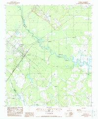
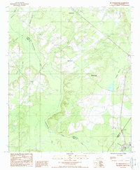 1988 Mc Phersonville1988 Print · USGSHampton and Jasper counties appear in the late eighties as a network of river-bound rural settlements. Genealogists and local researchers can trace the roads connecting Mcphersonville, Possum Corner, and Barkerville along the Coosawhatchie River.
 - 1988 Map of Grays
 1988 Grays1988 Print · USGSJasper and Hampton Counties in the late 1980s reveal a landscape of Lowcountry watercourses and small rural crossroads. Researchers can trace family history through local landmarks like Grays and several rural Cem sites near Cypress Creek.
End of results
Showing maps 1-14 of 14
Top cities of Jasper County
Frequently asked questions
- What are the different types of historical maps available for Jasper County?
- What is the oldest map of Jasper County?
- Where can I purchase historical maps of Jasper County for my home or office?
- Where can I download high-res historical maps of Jasper County?
- Are there historical topographic maps available for Jasper County?
- Is there historical aerial imagery available for Jasper County?
- Where are historical maps of Jasper County sourced from?