1990s Maps of West Columbia, South Carolina
Explore 2 historic maps of West Columbia from the 1990s. These maps offer a rare glimpse into what life looked like during the 1990s — showing old roads, neighborhoods, homes, and landmarks that have changed or disappeared over time.
Whether you're researching your family's past, planning a metal detecting trip, or studying how West Columbia's landscape evolved across the 1990s, these high-resolution maps are a powerful tool for exploring the history of this region.
- Focus on a specific era: All maps on this page are from the 1990s, giving you a focused view of this time period.
- See what’s changed: Compare century-old streets, trails, and buildings to today's modern landscape using overlays and satellite layers.
- Research with precision: Use these maps for genealogy, historical research, land use analysis, or educational projects.
- View, download, or print: Maps are fully viewable online in high resolution, and can be downloaded or printed for your own records.
Start exploring West Columbia's history through authentic maps from the 1990s. This is your window into the past.
West Columbia, SC maps
(2)- 1994 Map of Southwest Columbia, 2000 Print
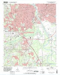 1994 Southwest Columbia2000 Print · USGSThe Congaree River corridor near the state capital was undergoing significant suburban and industrial expansion during the mid-nineties. Local historians can trace the development of Springdale and Pineridge alongside landmarks like the Styx State Fish Hatchery and Olympia Cem.
 - 1997 Map of Columbia North, 1999 Print
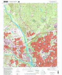 1997 Columbia North1999 Print · USGSThe state capital of Columbia stands at the river forks during the late nineties, showcasing a dense network of civic power and residential expansion. Researchers can trace institutional history at the State Capitol or locate ancestors in the historic Elmwood Cemetery and Palmetto Cem.
End of results
Showing maps 1-2 of 2
Top cities near West Columbia
- Columbia historical maps
- Lexington historical maps
- Cayce historical maps
- Forest Acres historical maps
- Blythewood historical maps
- Springdale historical maps
See more
Top neighborhoods of West Columbia
- Brookwood historical maps
- Triangle City historical maps
- Mill Village historical maps
- Park Place West historical maps
- Saluda Gardens historical maps
- Saluda Hills historical maps
See more
Frequently asked questions
- What are the different types of historical maps available for West Columbia?
- What is the oldest map of West Columbia?
- Where can I purchase historical maps of West Columbia for my home or office?
- Where can I download high-res historical maps of West Columbia?
- Are there historical topographic maps available for West Columbia?
- Is there historical aerial imagery available for West Columbia?
- Where are historical maps of West Columbia sourced from?