1900s (20th Century) Maps of Norris, South Carolina
Explore 10 historic maps of Norris from the 1900s (20th Century). These maps offer a rare glimpse into what life looked like during the 1900s — showing old roads, neighborhoods, homes, and landmarks that have changed or disappeared over time.
Whether you're researching your family's past, planning a metal detecting trip, or studying how Norris's landscape evolved across the 1900s, these high-resolution maps are a powerful tool for exploring the history of this region.
- Focus on a specific era: All maps on this page are from the 1900s, giving you a focused view of this time period.
- See what’s changed: Compare century-old streets, trails, and buildings to today's modern landscape using overlays and satellite layers.
- Research with precision: Use these maps for genealogy, historical research, land use analysis, or educational projects.
- View, download, or print: Maps are fully viewable online in high resolution, and can be downloaded or printed for your own records.
Start exploring Norris's history through authentic maps from the 1900s. This is your window into the past.
Norris, SC maps
(10)- 1951 Map of Clemson, 1952 Print
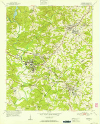 1951 Clemson1952 Print · USGSThe foothills of South Carolina come to life in the early fifties, centered on the growing campus of Clemson Agricultural College. Researchers can trace the Southern rail line through Central or locate family landmarks like Lawrence Chapel and Mt Zion Cem.6 unique versions available
 - 1954 Map of Greenville, 1965 Print
 1954 Greenville1965 Print · USGSThe Upstate and Northeast Georgia are captured here during a decade of massive transformation as new reservoirs reshaped the Piedmont. Genealogists and hikers can trace the Appalachian Trail over Brasstown Bald or locate old community centers like Demorest, Westminster, and Royston.3 unique versions available
 - 1957 Map of Anderson, 1958 Print
 1957 Anderson1958 Print · USGSUpstate South Carolina during the late fifties centers on the growth of Anderson and its surrounding textile and agricultural communities. Genealogists and local historians can trace family roots through numerous rural landmarks like McElmoyle Sch, Willis Chapel, and Sandy Springs.2 unique versions available
 - 1957 Map of Easley, 1958 Print
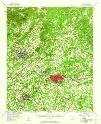 1957 Easley1958 Print · USGSIn the mid-1950s, the textile and rail corridor between Easley and Liberty hummed with Piedmont industry. Genealogists and local historians can trace family roots through numerous rural sites like Bruce-Hagood Cem, Dacusville, and the historic Pickensville settlement.2 unique versions available
 - 1958 Map of Greenville
 1958 Greenville1958 Print · USGSThe Piedmont and Blue Ridge foothills come alive in this mid-century survey of the Upstate and Northeast Georgia. Trace the regional rail-and-river economy through the Southern Railway corridors and early reservoir developments like Lake Sidney Lanier.
 - 1961 Map of Six Mile, 1964 Print
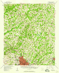
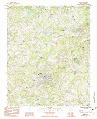
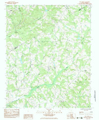
 1961 Six Mile1964 Print · USGSThis early 1960s survey of Pickens County captures the Piedmont landscape as the Hartwell Reservoir was beginning to shape the local geography. Genealogists can locate family landmarks like Mile Creek Ch, the community of Six Mile, and the rail-side town of Norris.3 unique versions available
 - 1983 Map of Liberty
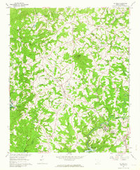
 1983 Liberty1983 Print · USGSThe Southern railway corridor and Piedmont foothills define this part of Pickens County in the early eighties. Researchers can trace family sites at Rices Creek Ch, locate the old Drive-In Theater, or survey the grounds of Hillcrest Memorial Park.2 unique versions available
 - 1983 Map of Five Forks
 1983 Five Forks1983 Print · USGSThe borderlands of Pickens and Anderson Counties are captured here in the early 1980s, revealing a landscape of small Piedmont communities and deep-rooted rural institutions. Genealogists can trace ancestral sites at Willis Chapel Cem, Sharon Ch, and along the banks of Three and Twenty Creek.
 - 1984 Map of Greenville
 1984 Greenville1984 Print · USGSThe South Carolina Upstate undergoes rapid suburban growth in the mid-eighties as modern interstates begin to reshape the landscape. Researchers can trace historic rail lines like the Greenville and Northern Railway and locate local landmarks such as Clemson University and Paris Mountain State Park.
 - 1991 Map of Greenville
 1991 Greenville1991 Print · USGSThe South Carolina Upstate was a landscape of rapid growth and engineering in the early nineties. Researchers can trace the expansion of Greenville and Spartanburg, find Clemson University, or study the massive reservoirs of Hartwell Lake and Lake Keowee.
End of results
Showing maps 1-10 of 10
Top cities near Norris
- Anderson historical maps
- Easley historical maps
- Clemson historical maps
- Seneca historical maps
- Central historical maps
- Liberty historical maps
See more
Frequently asked questions
- What are the different types of historical maps available for Norris?
- What is the oldest map of Norris?
- Where can I purchase historical maps of Norris for my home or office?
- Where can I download high-res historical maps of Norris?
- Are there historical topographic maps available for Norris?
- Is there historical aerial imagery available for Norris?
- Where are historical maps of Norris sourced from?