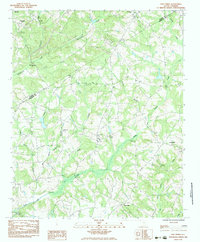
1983 Map of Five Forks
USGS Topo · Published 1983About this map
Norris sits at the northern edge of this Piedmont landscape, which is defined by a dense network of winding waterways and rural crossroads. The boundary between Pickens and Anderson Counties cuts diagonally across the terrain, passing near the settlement of Five Forks. This region is particularly rich in small community hubs, many centered on local landmarks like Midway No 2 Ch and White Oak Spring Ch.
Find a feature on this map
26 named features on this map. Tap any name to fly to it.
Don’t see what you’re looking for? This feature index may not catch every label — zoom into the map to look around manually.
Map Details
Editions of this 1983 Five Forks Map
This is the sole edition of this map. No revisions or reprints were ever made.
Other maps of this area

1888 · Pickens
USGS Topo · 1:125,000

1894 · Pickens
USGS Topo · 1:125,000

1950 · La France
USGS Topo · 1:24,000

1951 · La France
USGS Topo · 1:24,000

1951 · Clemson
USGS Topo · 1:24,000

1954 · Greenville
USGS Topo · 1:250,000

1957 · Anderson
USGS Topo · 1:62,500

1957 · Easley
USGS Topo · 1:62,500

1958 · Greenville
USGS Topo · 1:250,000
1961 · Six Mile
USGS Topo · 1:24,000