1970s Maps of Saluda County, South Carolina
Explore 9 historic maps of Saluda County from the 1970s. These maps offer a rare glimpse into what life looked like during the 1970s — showing old roads, neighborhoods, homes, and landmarks that have changed or disappeared over time.
Whether you're researching your family's past, planning a metal detecting trip, or studying how Saluda County's landscape evolved across the 1970s, these high-resolution maps are a powerful tool for exploring the history of this region.
- Focus on a specific era: All maps on this page are from the 1970s, giving you a focused view of this time period.
- See what’s changed: Compare century-old streets, trails, and buildings to today's modern landscape using overlays and satellite layers.
- Research with precision: Use these maps for genealogy, historical research, land use analysis, or educational projects.
- View, download, or print: Maps are fully viewable online in high resolution, and can be downloaded or printed for your own records.
Start exploring Saluda County's history through authentic maps from the 1970s. This is your window into the past.
Saluda County, SC maps
(9)- 1970 Map of Prosperity, 1973 Print
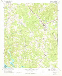 1970 Prosperity1973 Print · USGSNewberry County was a bustling rail and agricultural hub in the early 1970s, centered on the junction at Prosperity. You can trace rural landmarks from the Rikard Sch to numerous historic congregations like St Lukes Ch and Lever Chapel.
 - 1970 Map of Delmar, 1973 Print
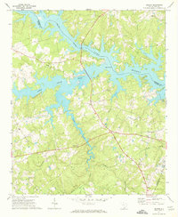 1970 Delmar1973 Print · USGSSaluda and Newberry Counties center on the expansive shoreline of the Saluda River Lake Murray reservoir in the early seventies. Genealogists and local historians can trace family locations near landmarks like Delmar, Utopia Sch, and the St Marks Ch churchyard.
 - 1971 Map of Saluda North, 1973 Print
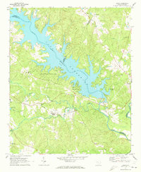
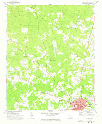 1971 Saluda North1973 Print · USGSThe town of Saluda and its outlying crossroads are captured here in the early 1970s, showing a landscape defined by small rural communities and creek-fed valleys. Researchers can locate family landmarks like Chestnut Hill Ch, Bleases Crossroads, and Riverside High Sch.
 - 1971 Map of Chappells, 1973 Print
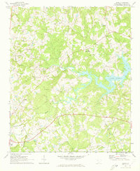
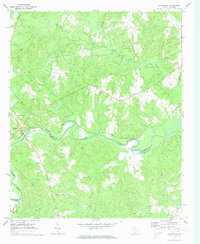 1971 Chappells1973 Print · USGSThe Saluda River valley in the early seventies remains a landscape of quiet rural communities and traditional river-and-rail geography. Genealogists can trace family roots through several country churches like Mt Nebo Ch and Crossroads Ch.
 - 1971 Map of Dyson, 1973 Print
 1971 Dyson1973 Print · USGSThe Piedmont landscape of the early seventies is dominated by the broad reaches of Lake Greenwood and the rural communities of the South Carolina backcountry. You can trace early church locations like Enoree Zion Ch and Salem Ch, or follow the Southern rail line through Dyson.
 - 1971 Map of Good Hope, 1973 Print
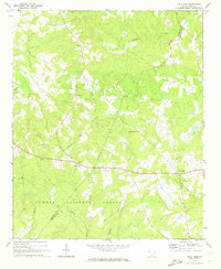 1971 Good Hope1973 Print · USGSThe rural Piedmont of the early 1970s is preserved here, showing the quiet transition between forest and farm. Researchers can trace family roots through several local congregations like Antioch Ch and White Rock Ch or find the rural crossroads of Friendship and Wertz.
 - 1971 Map of Denny, 1973 Print
 1971 Denny1973 Print · USGSSaluda County is shown during the early 1970s as rural life centered around the rising waters of Lake Murray. Genealogists and historians can trace community roots through sites like Mitchell Hill Cem, Hollywood High Sch, and Sardis Ch.
 - 1971 Map of Silverstreet, 1973 Print
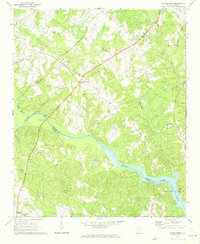 1971 Silverstreet1973 Print · USGSSilverstreet and the Saluda River valley are captured in the early seventies as Lake Murray reaches into Newberry County. Researchers can trace rural life through landmarks like Welch Zion Ch, Reuben Sch, and the historical crossing at Wateree Ferry.
 - 1971 Map of Lake Murray West, 1974 Print
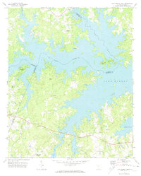 1971 Lake Murray West1974 Print · USGSThe intricate shoreline of South Carolina's largest reservoir is captured here in the early 1970s. Researchers can trace rural lineages through local landmarks like Red Star, Macedonia Ch, and the community at Ridge Road Crossroads.
End of results
Showing maps 1-9 of 9
Top cities of Saluda County
Frequently asked questions
- What are the different types of historical maps available for Saluda County?
- What is the oldest map of Saluda County?
- Where can I purchase historical maps of Saluda County for my home or office?
- Where can I download high-res historical maps of Saluda County?
- Are there historical topographic maps available for Saluda County?
- Is there historical aerial imagery available for Saluda County?
- Where are historical maps of Saluda County sourced from?