1960s Maps of Eureka Township, South Dakota
Explore 2 historic maps of Eureka Township from the 1960s. These maps offer a rare glimpse into what life looked like during the 1960s — showing old roads, neighborhoods, homes, and landmarks that have changed or disappeared over time.
Whether you're researching your family's past, planning a metal detecting trip, or studying how Eureka Township's landscape evolved across the 1960s, these high-resolution maps are a powerful tool for exploring the history of this region.
- Focus on a specific era: All maps on this page are from the 1960s, giving you a focused view of this time period.
- See what’s changed: Compare century-old streets, trails, and buildings to today's modern landscape using overlays and satellite layers.
- Research with precision: Use these maps for genealogy, historical research, land use analysis, or educational projects.
- View, download, or print: Maps are fully viewable online in high resolution, and can be downloaded or printed for your own records.
Start exploring Eureka Township's history through authentic maps from the 1960s. This is your window into the past.
Eureka Township, SD maps
(2)- 1968 Map of Brookings NE, 1970 Print
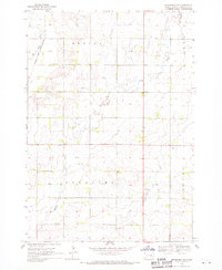 1968 Brookings NE1970 Print · USGSBrookings County at the end of the 1960s shows a landscape of prairie townships and vital river corridors. Genealogists can trace family roots at St Petri Cem or locate local landmarks like the Sterling Ch and the Townhall.2 unique versions available
 - 1968 Map of Bruce, 1970 Print
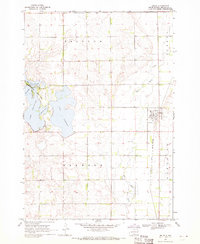 1968 Bruce1970 Print · USGSThe Brookings County plains come into focus in the late 1960s, showing the intersection of rail and river near the town of Bruce. Researchers can trace the Chicago and North Western tracks or locate family plots in the Bruce Cem and explore the shoreline of Lake Tetonkaha.
End of results
Showing maps 1-2 of 2
Top cities near Eureka Township
- Brookings historical maps
- Volga historical maps
- Estelline historical maps
- Castlewood historical maps
- White historical maps
- Aurora historical maps
See more
Frequently asked questions
- What are the different types of historical maps available for Eureka Township?
- What is the oldest map of Eureka Township?
- Where can I purchase historical maps of Eureka Township for my home or office?
- Where can I download high-res historical maps of Eureka Township?
- Are there historical topographic maps available for Eureka Township?
- Is there historical aerial imagery available for Eureka Township?
- Where are historical maps of Eureka Township sourced from?