Old Maps of Brown County, South Dakota for Metal Detecting
Plan your next treasure hunt with 127 historic maps of Brown County. Find old homesites, ghost towns, trails, and gathering spots that may be lost to time — perfect for identifying promising metal detecting locations.
- Locate forgotten sites: Uncover places like long-lost settlements, abandoned rail lines, or gathering spots.
- Plan better hunts: Use map overlays combined with LiDAR or satellite views to narrow in on historically rich areas.
- Made for detectorists: Thousands of hobbyists use these maps to discover relics, coins, and hidden history.
Use these historic maps to boost your research and find new opportunities beneath the surface of Brown County.
Brown County, SD maps
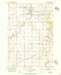
(127)- 1894 Map of Conde
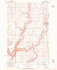
 1894 Conde1894 Print · USGSThe James River Valley region during the pioneer era of the 1890s reveals a landscape defined by the arrival of the rails. Trace the early township developments of Benton and Tetonka and locate early railway stops at Conde, Turton, and Verdon.
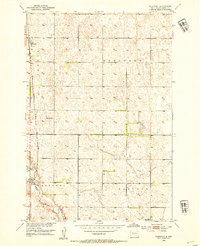
 - 1894 Map of Ellendale
 1894 Ellendale1894 Print · USGSDakota Territory transitions into new states in the late nineteenth century as the rail-and-river economy takes root. Genealogists can trace early township structures across Wheatland and Osceola, or locate residents near Frederick along the Chicago Milwaukee and St. Paul Railway.
 - 1894 Map of Hecla
 1894 Hecla1894 Print · USGSThe northern Dakota plains are captured here in the 1890s as the rail and river determined the pulse of new settlements. Genealogists and historians can trace the early township grids and rail stops like Hecla, Houghton, and the frontier hamlet of Detroit.4 unique versions available
 - 1894 Map of Columbia
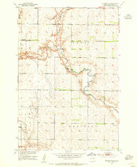
 1894 Columbia1894 Print · USGSBrown County in the 1890s reveals a prairie landscape defined by the winding James River and a growing railroad network. Genealogists and historians can trace early settlements like Columbia, Ordway, and Westport along the emerging lines of the Chicago and Northwestern.
 - 1894 Map of Savo
 1894 Savo1894 Print · USGSThe Dakota borderlands come into focus in the early 1890s, capturing the early township organization and rail development of the prairie. Genealogists and historians can trace the paths of the Maple River and the C. M. & St. P. R. R. through Frederick and Oneota.
 - 1895 Map of Aberdeen
 1895 Aberdeen1895 Print · USGSNortheastern South Dakota was rapidly evolving in the 1890s as a vital railroad corridor through the James River Valley. Local historians and genealogists can trace the early layout of rail-side towns like Warner, Groton, and the burgeoning hub of Aberdeen.4 unique versions available
 - 1896 Map of Columbia
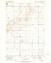
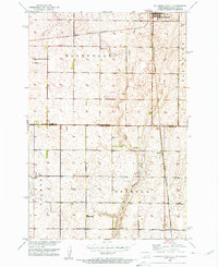
 1896 Columbia1896 Print · USGSSettlement along the upper James River valley flourished in the 1890s as railroads expanded through the Dakota Territory. Trace the rail-fed growth of Columbia and Hecla alongside the waters of Sand Lake and Lake Columbia.3 unique versions available
 - 1899 Map of Ellendale
 1899 Ellendale1899 Print · USGSNorth Dakota and South Dakota borderlands come into focus at the close of the nineteenth century as the railroad transforms the prairie. Genealogists and historians can trace the early growth of Ellendale and Leola along with vanished stops like Alpha and Delhi.2 unique versions available
 - 1899 Map of Northville
 1899 Northville1899 Print · USGSNortheastern South Dakota in the 1890s was a landscape defined by the expansion of the rails and the settlement of the prairie. You can trace the path of the Chicago and Northwestern RR through early townsites like Northville and Rudolph.2 unique versions available
 - 1952 Map of Huffton, 1954 Print
 1952 Huffton1954 Print · USGSBrown County's rural townships and rail-side settlements are captured here in the early fifties during a period of infrastructure transition. Researchers can locate the Great Northern rail line and several country schools like Happy Hour Sch and the Washington Sch (Abandoned).
 - 1952 Map of Columbia, 1954 Print
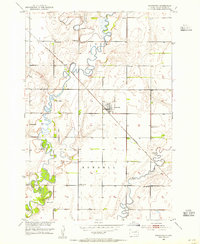
 1952 Columbia1954 Print · USGSBrown County’s river valleys and rail lines are captured here in the early fifties, showing the confluence of the James River and Elm River. Researchers can trace the path of the Great Northern railroad and locate rural landmarks like Davis Sch and Plana.
 - 1952 Map of Ordway, 1954 Print
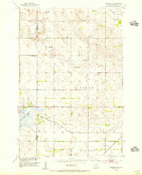
 1952 Ordway1954 Print · USGSMid-century Brown County is defined here by the winding Elm River and the rural rail crossroads at Ordway. Genealogists and local historians can trace the locations of the Thorson Sch, Prairie View Sch, and the Aberdeen Filtration Plant.
 - 1952 Map of Columbia NE, 1954 Print
 1952 Columbia NE1954 Print · USGSThe James River valley of Brown County is captured here in the early fifties, showing the interplay of irrigation and conservation. Genealogists can trace the rural school system and family plots at St Johns Cem or follow the Chicago and North Western rail line.
 - 1952 Map of Westport, 1954 Print
 1952 Westport1954 Print · USGSBrown County's prairie landscape is captured here in the early fifties, following the path of the Elm River through the townships of Oneota and Brainard. Genealogists and historians can trace the rail-side growth of Westport and Barnard or locate the rural Kelly Sch.2 unique versions available
 - 1952 Map of Richmond NE, 1954 Print
 1952 Richmond NE1954 Print · USGSBrown County's prairie landscape in the early fifties shows a rural community in transition as schools and small settlements consolidate. Researchers can locate family landmarks like the Westport Cem and trace the paths of Willow Creek and the Elm River.2 unique versions available
 - 1952 Map of Putney, 1954 Print
 1952 Putney1954 Print · USGSBrown County's rural townships and the meandering James River are captured here in the early fifties. Genealogists and local historians can trace schoolhouse sites like Riverside Sch and the rail-side community of Putney along the Great Northern line.
 - 1953 Map of Brentford, 1955 Print
 1953 Brentford1955 Print · USGSBrentford and the surrounding Spink County prairie are documented here in the early fifties during a period of rural school consolidation. Genealogists can trace the Plainview Cemetery and the sites of School No 3 and School No 1.
 - 1953 Map of Savo SW, 1955 Print
 1953 Savo SW1955 Print · USGSBrown County's rural townships are documented here in the early fifties, showing the settlement patterns of a Missouri River Basin community. Genealogists can locate family-named sites like Savo Cem and rural schools including Sumption Sch and School No 1.
 - 1953 Map of Frederick, 1955 Print
 1953 Frederick1955 Print · USGSMid-century Brown County is documented here during the Missouri River Basin development era, centered on the rail-side town of Frederick. Genealogists can locate rural landmarks like School No 10 and the site of School No 2 near the Maple River.2 unique versions available
 - 1953 Map of Ellendale South, 1955 Print
 1953 Ellendale South1955 Print · USGSThe borderlands of North and South Dakota are captured here in the early fifties, centering on the rail hub of Ellendale. Genealogists and historians can locate rural schoolhouses like Gustafson Sch and Senn Sch along with the path of the Great Northern railroad.3 unique versions available
 - 1953 Map of Stratford, 1955 Print
 1953 Stratford1955 Print · USGSBrown County, South Dakota, is captured here in the mid-fifties as a thriving rail-and-river agricultural community centered on the town of Stratford. Researchers can trace the legacy of rural education and faith through landmarks like Sunnyview Sch, Midway Sch, and the local Lutheran Ch.
 - 1953 Map of Hecla SE, 1955 Print
 1953 Hecla SE1955 Print · USGSBrown County's rural prairie landscape is captured here in the early fifties, a time when drainage ditches and artesian wells defined local agriculture. Researchers can locate the Detroit Cem, the Landing Field, and several country schools like Heipemann Sch.2 unique versions available
 - 1953 Map of Houghton, 1955 Print
 1953 Houghton1955 Print · USGSBrown County's marshy James River valley is captured here in the early fifties during the development of the Missouri River Basin project. Genealogists and researchers can locate the village of Houghton, local landmarks like Fangon Sch, and the extensive Sand Lake Reservoir.2 unique versions available
 - 1953 Map of Groton SW, 1955 Print
 1953 Groton SW1955 Print · USGSBrown County's agricultural heartland is captured here in the early fifties, showing a rural landscape organized by township sections. Genealogists can trace local history through a series of schoolhouses including Hanson Sch, School No 8, and the Minneapolis and St Louis railroad line.
 - 1953 Map of Newark SW, 1955 Print
 1953 Newark SW1955 Print · USGSThe borderlands of Marshall and Brown Counties are captured here in the mid-1950s, showing a landscape shaped by water management and rail. Researchers can locate the Great Northern tracks, the rural School No 3, and hydrology like Flowing Well.
Showing maps 1-25 of 127
Frequently asked questions
- What are the different types of historical maps available for Brown County?
- What is the oldest map of Brown County?
- Where can I purchase historical maps of Brown County for my home or office?
- Where can I download high-res historical maps of Brown County?
- Are there historical topographic maps available for Brown County?
- Is there historical aerial imagery available for Brown County?
- Where are historical maps of Brown County sourced from?