1970s Maps of Brule Township, South Dakota
Explore 2 historic maps of Brule Township from the 1970s. These maps offer a rare glimpse into what life looked like during the 1970s — showing old roads, neighborhoods, homes, and landmarks that have changed or disappeared over time.
Whether you're researching your family's past, planning a metal detecting trip, or studying how Brule Township's landscape evolved across the 1970s, these high-resolution maps are a powerful tool for exploring the history of this region.
- Focus on a specific era: All maps on this page are from the 1970s, giving you a focused view of this time period.
- See what’s changed: Compare century-old streets, trails, and buildings to today's modern landscape using overlays and satellite layers.
- Research with precision: Use these maps for genealogy, historical research, land use analysis, or educational projects.
- View, download, or print: Maps are fully viewable online in high resolution, and can be downloaded or printed for your own records.
Start exploring Brule Township's history through authentic maps from the 1970s. This is your window into the past.
Brule Township, SD maps
(2)- 1974 Map of Red Lake West, 1977 Print
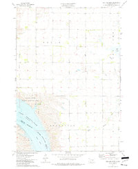 1974 Red Lake West1977 Print · USGSBrule and Lyman Counties are captured in the mid-seventies, showing the Missouri River's transformation into the massive Lake Francis Case. Researchers can locate family landmarks like Grandview Cem and trace the course of Reimer Creek toward the reservoir.
 - 1974 Map of Chamberlain, 1977 Print
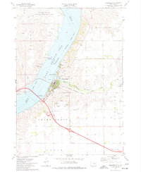 1974 Chamberlain1977 Print · USGSChamberlain occupies a strategic riverfront position in the 1970s, where rail and road infrastructure meets the Missouri. Researchers can locate long-standing landmarks like St Josephs Indian School, trace the Milwaukee Road railroad, and find the old Drive-in Theater.
End of results
Showing maps 1-2 of 2
Top cities near Brule Township
- Chamberlain historical maps
- Oacoma historical maps
- Pukwana historical maps
- Ideal Segment historical maps
- Ola historical maps
- Iona historical maps
Frequently asked questions
- What are the different types of historical maps available for Brule Township?
- What is the oldest map of Brule Township?
- Where can I purchase historical maps of Brule Township for my home or office?
- Where can I download high-res historical maps of Brule Township?
- Are there historical topographic maps available for Brule Township?
- Is there historical aerial imagery available for Brule Township?
- Where are historical maps of Brule Township sourced from?