Old Maps of Little Eagle, South Dakota for Metal Detecting
Plan your next treasure hunt with 76 historic maps of Little Eagle. Find old homesites, ghost towns, trails, and gathering spots that may be lost to time — perfect for identifying promising metal detecting locations.
- Locate forgotten sites: Uncover places like long-lost settlements, abandoned rail lines, or gathering spots.
- Plan better hunts: Use map overlays combined with LiDAR or satellite views to narrow in on historically rich areas.
- Made for detectorists: Thousands of hobbyists use these maps to discover relics, coins, and hidden history.
Use these historic maps to boost your research and find new opportunities beneath the surface of Little Eagle.
Little Eagle, SD maps
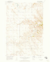
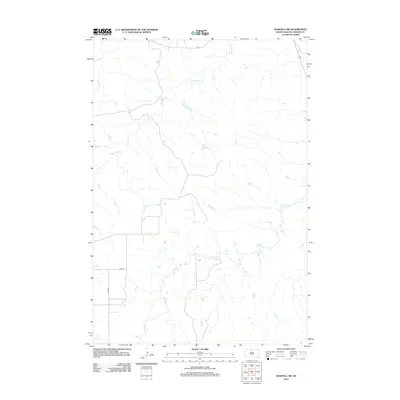
(76)- 1953 Map of McIntosh, 1965 Print
 1953 McIntosh1965 Print · USGSThe north-central Dakota prairie is captured here during the mid-fifties, showing the vast Standing Rock Indian Reservation and the newly formed Oah E Reservoir. Genealogists and historians can trace the Chicago Milwaukee St Paul and Pacific rail line through stops like McIntosh, Walker, and Eagle Butte.3 unique versions available
 - 1956 Map of Little Eagle SW, 1957 Print
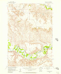
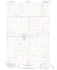
 1956 Little Eagle SW1957 Print · USGSCorson County ranchlands appear in the mid-1950s as the Missouri River Basin development program was underway. Researchers can locate family landmarks like the Good Shepherd Ch, the Meyer Sch, and the Spring Lake Sch (Abandoned).2 unique versions available
 - 1956 Map of Wakpala NW, 1957 Print
 1956 Wakpala NW1957 Print · USGSCorson County land along the Grand River is captured here in the mid-1950s during a period of Missouri River Basin development. Genealogists and local historians can locate Sacred Heart Cem, Long Hill Cem, and the path of the Chicago Milwaukee St Paul and Pacific railroad.2 unique versions available
 - 1956 Map of Little Eagle, 1957 Print
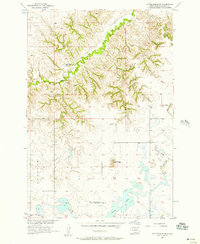
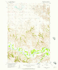
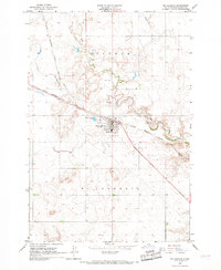
 1956 Little Eagle1957 Print · USGSIn the mid-1950s, the community of Little Eagle sat along the winding Grand River on the Standing Rock Reservation. Genealogists and historians can trace the town's social fabric through landmarks like St Pauls Ch and St Pauls Cem.2 unique versions available
 - 1956 Map of Little Eagle SE, 1957 Print
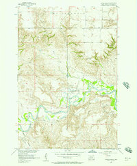
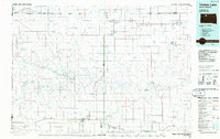
 1956 Little Eagle SE1957 Print · USGSCorson County prairie life in the mid-1950s is documented here through its rural school districts and winding waterways. Researchers can locate the Harding Sch (Abandoned), Reinbold Sch, and the landmark Runaround Butte.
 - 1956 Map of Miscol SE, 1957 Print
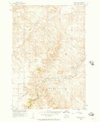
 1956 Miscol SE1957 Print · USGSCorson County rural life in the mid-1950s reveals a landscape of upland ridges and quiet prairie streams. Genealogists and local historians can trace the foundations of the community at the Chapel Sch and Long Butte Sch along High Bank Creek.2 unique versions available
 - 1956 Map of Little Eagle NW, 1957 Print
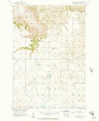
 1956 Little Eagle NW1957 Print · USGSThe Missouri River Basin in the mid-1950s was a landscape of remote river crossings and rural prairie parishes. Genealogists and historians can trace local landmarks like the Little Oak Creek Ch, the Ford crossing on the Grand River, and the settlement at Eagle.2 unique versions available
 - 1956 Map of Wakpala SW, 1957 Print
 1956 Wakpala SW1957 Print · USGSCorson County’s dissected landscape is captured here in the mid-fifties, showing the rugged breaks of the Missouri River Basin. Trace the path of the Chicago Milwaukee St Paul and Pacific railroad as it winds past Skull Peak and follows Snake Creek.2 unique versions available
 - 1956 Map of Miscol NE, 1957 Print
 1956 Miscol NE1957 Print · USGSThe winding loops of the Grand River dominate this mid-century South Dakota landscape. Researchers can trace the path of Plum Creek or locate several seasonal river Ford crossings used throughout the Missouri River Basin.
 - 1958 Map of McIntosh
 1958 McIntosh1958 Print · USGSThe north-central Dakotas appear here in the mid-1950s as massive engineering projects and rail lines shaped the plains. Researchers can trace tribal lands within the Standing Rock Indian Reservation and locate local landmarks like the Keller Mine or the Virginia Siding.
 - 1966 Map of McLaughlin, 1967 Print
 1966 McLaughlin1967 Print · USGSMcLaughlin and the surrounding plains of Corson County are captured here in the mid-1960s as a vital railroad town. Researchers can trace the town's footprint along the Chicago Milwaukee St Paul and Pacific line, locating the Protestant Cem and the local Landing Strip.2 unique versions available
 - 1971 Map of McLaughlin SW, 1974 Print
 1971 McLaughlin SW1974 Print · USGSCorson County's wide-open prairie and township lines are captured here in the early 1970s. Genealogists and rail historians can trace the path of the Chicago Milwaukee St Paul and Pacific through the Lincoln and Cadillac districts.
 - 1975 Map of Glencross, 1978 Print
 1975 Glencross1978 Print · USGSDewey County, South Dakota, is captured here in the mid-1970s at the intersection of two major tribal lands. Researchers can trace the rail corridor of the Chicago Milwaukee St Paul and Pacific through Glencross and locate the Sacred Heart Cem.
 - 1975 Map of Trail City, 1978 Print
 1975 Trail City1978 Print · USGSTrail City in the mid-seventies occupies a unique position on the boundary between the Standing Rock and Cheyenne River Indian Reservations. Researchers can trace the path of the Chicago Milwaukee St Paul and Pacific railroad through the townsite and locate the Trail City Cem and Trail City Lake.
 - 1975 Map of Glencross NE, 1978 Print
 1975 Glencross NE1978 Print · USGSThe northern plains of South Dakota are captured in the mid-seventies, showing the intersection of tribal and county lands. Researchers can trace the path of the Chicago Milwaukee St Paul and Pacific rail line past Trail City RR Lake and the winding Handboy Creek.
 - 1978 Map of Timber Lake, 1979 Print
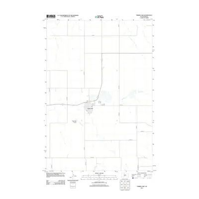
 1978 Timber Lake1979 Print · USGSTimber Lake and the surrounding plains of the Standing Rock Indian Reservation are captured here in the late seventies. Researchers can trace the Chicago Milwaukee St Paul and Pacific rail corridor or locate family sites at Holy Cross Cem and Timber Lake.2 unique versions available
 - 1980 Map of McIntosh, 1981 Print
 1980 McIntosh1981 Print · USGSThe northern plains of the Standing Rock Indian Reservation are shown here as they appeared in the early 1980s. You can trace the railroad history of Corson County along the Chicago Milwaukee St Paul and Pacific line, connecting settlements like Watauga and Morristown.
 - 1985 Map of Mobridge
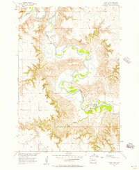
 1985 Mobridge1985 Print · USGSCrossing the Missouri River in the mid-1980s, this landscape reveals the intersection of the Standing Rock Indian Reservation and the rising waters of Lake Oahe. Researchers can locate significant historical markers such as Sitting Bulls Grave, St Elizabeth Mission Home, and the Leavenworth Monument.2 unique versions available
 - 1985 Map of La Plant, 1986 Print
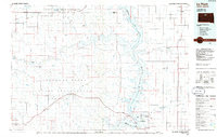 1985 La Plant1986 Print · USGSThe Cheyenne River and Standing Rock Indian Reservations meet here in the mid-eighties as Lake Oahe reshapes the Missouri River valley. Genealogists and local historians can trace the Old RR Gr and locate community landmarks like La Plant, Whitehorse, and Rabenberg Cemetery.2 unique versions available
 - 1986 Map of Timber Lake
 1986 Timber Lake1986 Print · USGSNorth-central South Dakota in the mid-eighties reveals a landscape of ranching hubs and indigenous lands shaped by the Moreau River and Grand River. Researchers can trace old rail routes near Red Elm and locate remote prairie landmarks like St Patrick Butte or Glad Valley.2 unique versions available
 - 2012 Map of Timber Lake, 2012 Print
 2012 Timber Lake2012 Print · USGSCovers Little Eagle, including Timber Lake, Rock Creek District, and other nearby areas
 - 2012 Map of Miscol SE, 2012 Print
 2012 Miscol SE2012 Print · USGSCovers Little Eagle, including Rock Creek District, Corson County, and other nearby areas
 - 2012 Map of Miscol NE, 2012 Print
 2012 Miscol NE2012 Print · USGSCovers Little Eagle, including Rock Creek District, Corson County, and other nearby areas
 - 2012 Map of Glencross NE, 2012 Print
 2012 Glencross NE2012 Print · USGSCovers Little Eagle, including District 6, District 4, and other nearby areas
 - 2012 Map of Wakpala SW, 2012 Print
 2012 Wakpala SW2012 Print · USGSCovers Little Eagle, including Wakpala, Corson County, and other nearby areas
Showing maps 1-25 of 76
Top cities near Little Eagle
- McLaughlin historical maps
- McLaughlin historical maps
- Timber Lake historical maps
- Wakpala historical maps
Frequently asked questions
- What are the different types of historical maps available for Little Eagle?
- What is the oldest map of Little Eagle?
- Where can I purchase historical maps of Little Eagle for my home or office?
- Where can I download high-res historical maps of Little Eagle?
- Are there historical topographic maps available for Little Eagle?
- Is there historical aerial imagery available for Little Eagle?
- Where are historical maps of Little Eagle sourced from?