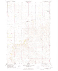
1975 Map of Glencross NE
USGS Topo · Published 1978About this map
The Chicago Milwaukee St Paul and Pacific railroad tracks bisect this prairie landscape, providing a vital east-west corridor through the northern plains of South Dakota in the mid-1970s. This survey focuses on the border between Corson Co and Dewey Co, illustrating the intersection of civil administrative boundaries and the Standing Rock Indian Reservation Boundary.
Find a feature on this map
6 named features on this map. Tap any name to fly to it.
Don’t see what you’re looking for? This feature index may not catch every label — zoom into the map to look around manually.
Map Details
Editions of this 1975 Glencross NE Map
This is the sole edition of this map. No revisions or reprints were ever made.
Other maps of this area

1952 · Whitehorse
USGS Topo · 1:24,000

1952 · Trail City SW
USGS Topo · 1:24,000

1952 · Glencross SE
USGS Topo · 1:24,000

1953 · McIntosh
USGS Topo · 1:250,000

1956 · Little Eagle SW
USGS Topo · 1:24,000

1956 · Little Eagle SE
USGS Topo · 1:24,000

1956 · Wakpala SW
USGS Topo · 1:24,000

1958 · McIntosh
USGS Topo · 1:250,000

1975 · Glencross
USGS Topo · 1:24,000

1975 · Trail City
USGS Topo · 1:24,000