
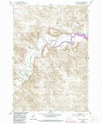
1952 Map of Trail City SW
USGS Topo · Published 1954About this map
The Cheyenne River Indian Reservation landscape is defined by the winding course of the Moreau River, which carves deep meanders across this South Dakota terrain. This 1952 field-checked survey reveals a sparsely settled region focused on the river valley, where St Marys Ch stands as a primary landmark above the northern banks. The intricate drainage network is mapped in detail, showing how intermittent streams like Handboy Creek, Marshall Creek, and Black Beaver Creek feed into the main river system. This map was produced as part of the Department of the Interior's post-war program for the development of the Missouri River Basin, capturing the topography of Dewey County before modern agricultural and infrastructure changes. The terrain is characterized by sharp elevation shifts between the river bottomlands and the surrounding breaks, with Swan Cr and Mullen Creek marking the southwestern reaches of the quadrangle.
Find a feature on this map
9 named features on this map. Tap any name to fly to it.
Don’t see what you’re looking for? This feature index may not catch every label — zoom into the map to look around manually.
Map Details
Editions of this 1952 Trail City SW Map
2 editions found
Other maps of this area

1951 · Virginia
USGS Topo · 1:24,000

1951 · Ridgeview NE
USGS Topo · 1:24,000

1951 · La Plant
USGS Topo · 1:24,000

1951 · Promise
USGS Topo · 1:24,000

1952 · Glencross SE
USGS Topo · 1:24,000

1953 · McIntosh
USGS Topo · 1:250,000

1958 · McIntosh
USGS Topo · 1:250,000

1975 · Laundreaux Butte
USGS Topo · 1:24,000

1975 · Trail City
USGS Topo · 1:24,000
1975 · Glencross NE
USGS Topo · 1:24,000