1960s Maps of Haakon County, South Dakota
Explore 3 historic maps of Haakon County from the 1960s. These maps offer a rare glimpse into what life looked like during the 1960s — showing old roads, neighborhoods, homes, and landmarks that have changed or disappeared over time.
Whether you're researching your family's past, planning a metal detecting trip, or studying how Haakon County's landscape evolved across the 1960s, these high-resolution maps are a powerful tool for exploring the history of this region.
- Focus on a specific era: All maps on this page are from the 1960s, giving you a focused view of this time period.
- See what’s changed: Compare century-old streets, trails, and buildings to today's modern landscape using overlays and satellite layers.
- Research with precision: Use these maps for genealogy, historical research, land use analysis, or educational projects.
- View, download, or print: Maps are fully viewable online in high resolution, and can be downloaded or printed for your own records.
Start exploring Haakon County's history through authentic maps from the 1960s. This is your window into the past.
Haakon County, SD maps
(3)- 1961 Map of Cottonwood
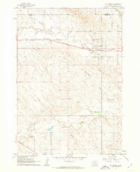 1961 Cottonwood1961 Print · USGSCottonwood and the surrounding prairie are captured in the early sixties as the railroad still anchored the local economy. Genealogists and historians can trace family-named landmarks like Ackerman Hill or locate the Hi-Way Sch and Cottonwood Cem.2 unique versions available
 - 1961 Map of Cottonwood NE, 1963 Print
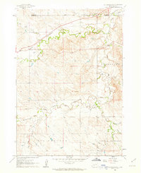 1961 Cottonwood NE1963 Print · USGSThe high prairie of Jackson County was a land of winding creek beds and remote rail sidings in the early sixties. You can trace the path of the CHICAGO AND NORTH WESTERN railroad and locate rural landmarks like Fairview Sch and the Landing Strip.2 unique versions available
 - 1961 Map of Wall NE, 1963 Print
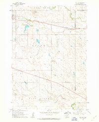 1961 Wall NE1963 Print · USGSThe town of Quinn and the surrounding ranchlands are documented here in the early 1960s at the intersection of three counties. Genealogists and local historians can trace landmarks like Mt Hope Cem, the Cottonwood Sch, and the Chicago and North Western railroad.2 unique versions available
End of results
Showing maps 1-3 of 3
Top cities of Haakon County
Frequently asked questions
- What are the different types of historical maps available for Haakon County?
- What is the oldest map of Haakon County?
- Where can I purchase historical maps of Haakon County for my home or office?
- Where can I download high-res historical maps of Haakon County?
- Are there historical topographic maps available for Haakon County?
- Is there historical aerial imagery available for Haakon County?
- Where are historical maps of Haakon County sourced from?