1940s Maps of Hand County, South Dakota
Explore 3 historic maps of Hand County from the 1940s. These maps offer a rare glimpse into what life looked like during the 1940s — showing old roads, neighborhoods, homes, and landmarks that have changed or disappeared over time.
Whether you're researching your family's past, planning a metal detecting trip, or studying how Hand County's landscape evolved across the 1940s, these high-resolution maps are a powerful tool for exploring the history of this region.
- Focus on a specific era: All maps on this page are from the 1940s, giving you a focused view of this time period.
- See what’s changed: Compare century-old streets, trails, and buildings to today's modern landscape using overlays and satellite layers.
- Research with precision: Use these maps for genealogy, historical research, land use analysis, or educational projects.
- View, download, or print: Maps are fully viewable online in high resolution, and can be downloaded or printed for your own records.
Start exploring Hand County's history through authentic maps from the 1940s. This is your window into the past.
Hand County, SD maps
(3)- 1949 Map of Ree Heights NW, 1967 Print
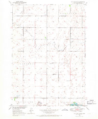 1949 Ree Heights NW1967 Print · USGSHand County is captured here in the late 1940s, highlighting a landscape of rural schoolhouses and water resources. Local historians can trace the foundations of the community at Van Zee Sch, NE Riverside Sch, and the Flowing Well sites near Lake Louise.
 - 1949 Map of Vayland SE, 1976 Print
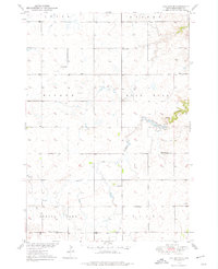 1949 Vayland SE1976 Print · USGSHand County townships are mapped here in the late 1940s, showing a landscape defined by prairie agriculture and rural school districts. Genealogists can trace early homestead life through the locations of Rose Hill Ch, Cem, and Rowen Sch.
 - 1949 Map of Vayland SW, 1976 Print
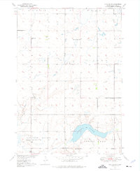 1949 Vayland SW1976 Print · USGSHand County prairie life is documented here during the late 1940s, showing a landscape defined by township grids and rural school districts. Researchers can pinpoint several local landmarks like Spring Lake, Pleasant Valley Ch, and Horseshoe Bend Sch.
End of results
Showing maps 1-3 of 3
Top cities of Hand County
- Miller historical maps
- St. Lawrence historical maps
- Ree Heights historical maps
- Burdette historical maps
Frequently asked questions
- What are the different types of historical maps available for Hand County?
- What is the oldest map of Hand County?
- Where can I purchase historical maps of Hand County for my home or office?
- Where can I download high-res historical maps of Hand County?
- Are there historical topographic maps available for Hand County?
- Is there historical aerial imagery available for Hand County?
- Where are historical maps of Hand County sourced from?