1910s Maps of Lawrence County, South Dakota
Explore 3 historic maps of Lawrence County from the 1910s. These maps offer a rare glimpse into what life looked like during the 1910s — showing old roads, neighborhoods, homes, and landmarks that have changed or disappeared over time.
Whether you're researching your family's past, planning a metal detecting trip, or studying how Lawrence County's landscape evolved across the 1910s, these high-resolution maps are a powerful tool for exploring the history of this region.
- Focus on a specific era: All maps on this page are from the 1910s, giving you a focused view of this time period.
- See what’s changed: Compare century-old streets, trails, and buildings to today's modern landscape using overlays and satellite layers.
- Research with precision: Use these maps for genealogy, historical research, land use analysis, or educational projects.
- View, download, or print: Maps are fully viewable online in high resolution, and can be downloaded or printed for your own records.
Start exploring Lawrence County's history through authentic maps from the 1910s. This is your window into the past.
Lawrence County, SD maps
(3)- 1915 Map of Spearfish
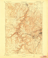 1915 Spearfish1915 Print · USGSLawrence County in the early twentieth century is a landscape of gold mining camps and mountain railroads. Genealogists and historians can trace the foundations of Lead and Spearfish, or find now-quiet locations like Homestake Camp and Carbonate.2 unique versions available
 - 1915 Map of Sturgis
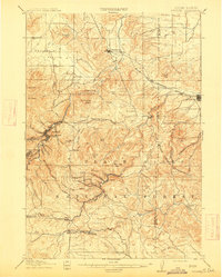 1915 Sturgis1915 Print · USGSThe Black Hills were a hub of mining and military activity in the early twentieth century. Researchers can trace the rail lines of the Chicago and Northwestern and locate specialized sites like the Golden Crest Mine and the Fort Meade Military Reservation.2 unique versions available
 - 1916 Map of Deadwood
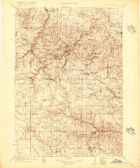 1916 Deadwood1916 Print · USGSThe Black Hills mining district at the peak of its early industrial era shows a dense network of rail and timber camps. Researchers can trace the narrow-gauge C B & Q RR lines to the Queen Bee Mine and the Fort Meade Military Reservation.3 unique versions available
End of results
Showing maps 1-3 of 3
Top cities of Lawrence County
- Spearfish historical maps
- Lead historical maps
- North Spearfish historical maps
- Deadwood historical maps
- Whitewood historical maps
- Mountain Plains historical maps
See more
Frequently asked questions
- What are the different types of historical maps available for Lawrence County?
- What is the oldest map of Lawrence County?
- Where can I purchase historical maps of Lawrence County for my home or office?
- Where can I download high-res historical maps of Lawrence County?
- Are there historical topographic maps available for Lawrence County?
- Is there historical aerial imagery available for Lawrence County?
- Where are historical maps of Lawrence County sourced from?