1960s Maps of Lawrence County, South Dakota
Explore 7 historic maps of Lawrence County from the 1960s. These maps offer a rare glimpse into what life looked like during the 1960s — showing old roads, neighborhoods, homes, and landmarks that have changed or disappeared over time.
Whether you're researching your family's past, planning a metal detecting trip, or studying how Lawrence County's landscape evolved across the 1960s, these high-resolution maps are a powerful tool for exploring the history of this region.
- Focus on a specific era: All maps on this page are from the 1960s, giving you a focused view of this time period.
- See what’s changed: Compare century-old streets, trails, and buildings to today's modern landscape using overlays and satellite layers.
- Research with precision: Use these maps for genealogy, historical research, land use analysis, or educational projects.
- View, download, or print: Maps are fully viewable online in high resolution, and can be downloaded or printed for your own records.
Start exploring Lawrence County's history through authentic maps from the 1960s. This is your window into the past.
Lawrence County, SD maps
(7)- 1961 Map of Maurice, 1962 Print
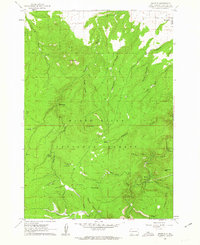 1961 Maurice1962 Print · USGSThe Black Hills northwest of Spearfish were a rugged nexus of early transport and water management in the early sixties. Genealogists and historians can trace the routes of Tollgate Road and Sawmill Road or locate the settlement at Maurice near Bridal Veil Falls.5 unique versions available
 - 1961 Map of Lead, 1963 Print
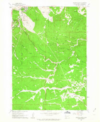
 1961 Lead1963 Print · USGSThe Black Hills mining district comes alive in the early 1960s as extraction operations and mountain settlements define the landscape. Researchers can trace the rail lines of the Burlington and Quincy through Terraville or locate family roots near Englewood Cemetery and Trojan.3 unique versions available
 - 1961 Map of Savoy, 1963 Print
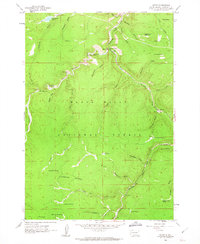 1961 Savoy1963 Print · USGSDeep in the Black Hills during the early sixties, this survey captures a landscape defined by dramatic waterfalls and high plateaus. Researchers can trace the layout of Savoy, find the Cemetery near Preston, or locate the Little Spearfish Guard Station.4 unique versions available
 - 1961 Map of Deadwood South, 1963 Print
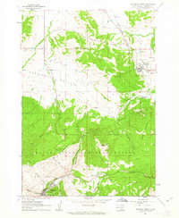
 1961 Deadwood South1963 Print · USGSThe Black Hills gold country comes into sharp focus during the early 1960s, showing the intersection of mining history and modern recreation. Trace family ties and land use near Deadwood, the Chicago Burlington and Quincy rails, and the mining camp at Galena.5 unique versions available
 - 1961 Map of Deadwood North, 1963 Print
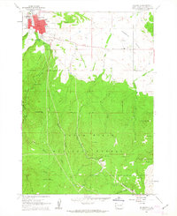
 1961 Deadwood North1963 Print · USGSNorthern Lawrence County in the early sixties reveals a landscape shaped by mining and rail history. Trace the legacy of the Old West through Deadwood landmarks like the Seth Bullock Grave, Mt Moriah Cem, and the old Crook City site.4 unique versions available
 - 1961 Map of Spearfish, 1963 Print
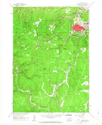
 1961 Spearfish1963 Print · USGSSpearfish and the northern Black Hills are captured here in the early sixties, showing a landscape of college town growth and forested backcountry. Trace local history through the Black Hills Teachers College campus or find the Mount Theodore Roosevelt Monument and Maitland settlement.6 unique versions available
 - 1962 Map of Gillette
 1962 Gillette1962 Print · USGSHigh plains ranching and coal mining dominate the Powder River Basin in the early sixties. Genealogists can trace rural communities through landmarks like the Bethlehem Church, Lake School, and settlements such as Moorcroft and Sundance.
End of results
Showing maps 1-7 of 7
Top cities of Lawrence County
- Spearfish historical maps
- Lead historical maps
- North Spearfish historical maps
- Deadwood historical maps
- Whitewood historical maps
- Mountain Plains historical maps
See more
Frequently asked questions
- What are the different types of historical maps available for Lawrence County?
- What is the oldest map of Lawrence County?
- Where can I purchase historical maps of Lawrence County for my home or office?
- Where can I download high-res historical maps of Lawrence County?
- Are there historical topographic maps available for Lawrence County?
- Is there historical aerial imagery available for Lawrence County?
- Where are historical maps of Lawrence County sourced from?