
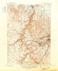
1915 Map of Spearfish
USGS Topo · Published 1915About this map
Black Hills National Forest dominates this landscape, revealing a dense network of mining camps and mountain settlements established during the peak of the regional gold boom. The industrial heart of the region is centered on Lead, where the Golden Reward Mine and the Flatiron Mine signify the intensive extraction of the era. Transportation routes are defined by the Burlington and Missouri River R.R., which winds through the steep gulches to reach high-altitude hubs like Trojan and Terry. Further north, Spearfish serves as a gateway at the mouth of Spearfish Creek, contrasting with the more industrial character of North Lead and Central City. This survey captures the complex topography of the Limestone Plateau and the deeply incised Rubicon Gulch, illustrating how geology dictated the placement of every railroad spur and mining claim during the early twentieth century.
Find a feature on this map
88 named features on this map. Tap any name to fly to it.
Don’t see what you’re looking for? This feature index may not catch every label — zoom into the map to look around manually.
Map Details
Editions of this 1915 Spearfish Map
2 editions found
Other maps of this area

1894 · Deadwood
USGS Topo · 1:125,000

1898 · Sundance
USGS Topo · 1:125,000

1899 · Sturgis
USGS Topo · 1:62,500

1900 · Spearfish
USGS Topo · 1:62,500

1901 · Deadwood
USGS Topo · 1:125,000

1901 · Aladdin
USGS Topo · 1:125,000

1902 · Sundance
USGS Topo · 1:125,000

1903 · Aladdin
USGS Topo · 1:125,000

1905 · Saint Onge
USGS Topo · 1:62,500

1907 · Belle Fourche
USGS Topo · 1:125,000