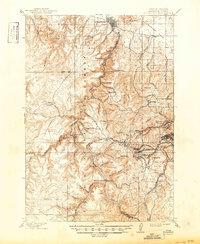
1915 Map of Spearfish
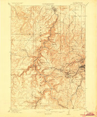
USGS Topo · Published 1950About this map
Spearfish serves as the gateway to this industrial landscape, where the northern Black Hills reveal a dense concentration of early mining settlements and deep mountain gulches. Based on surveys from 1898 and 1913, the map documents the vertical world of the gold boom, centering on the significant operations at Lead and the Homestake Camp. The intricate rail network required to service these mountain outposts is clearly defined, including the winding routes of the Burlington and Missouri River R.R. and the Deadwood Central R.R., which navigated steep grades to reach sites like Terry and Trojan. Along the dramatic corridor of Spearfish Creek, the map identifies natural landmarks such as Bridalveil Falls and Spearfish Falls, alongside specialized camps and small mining hamlets like Carbonate and Cyanide that once dotted these narrow canyons.
Find a feature on this map
100 named features on this map. Tap any name to fly to it.
Don’t see what you’re looking for? This feature index may not catch every label — zoom into the map to look around manually.
Map Details
Editions of this 1915 Spearfish Map
2 editions found
Other maps of this area

1894 · Deadwood
USGS Topo · 1:125,000

1898 · Sundance
USGS Topo · 1:125,000

1899 · Sturgis
USGS Topo · 1:62,500

1900 · Spearfish
USGS Topo · 1:62,500

1901 · Deadwood
USGS Topo · 1:125,000

1901 · Aladdin
USGS Topo · 1:125,000

1902 · Sundance
USGS Topo · 1:125,000

1903 · Aladdin
USGS Topo · 1:125,000

1905 · Saint Onge
USGS Topo · 1:62,500

1907 · Belle Fourche
USGS Topo · 1:125,000