1950s Maps of Porcupine, South Dakota
Explore 10 historic maps of Porcupine from the 1950s. These maps offer a rare glimpse into what life looked like during the 1950s — showing old roads, neighborhoods, homes, and landmarks that have changed or disappeared over time.
Whether you're researching your family's past, planning a metal detecting trip, or studying how Porcupine's landscape evolved across the 1950s, these high-resolution maps are a powerful tool for exploring the history of this region.
- Focus on a specific era: All maps on this page are from the 1950s, giving you a focused view of this time period.
- See what’s changed: Compare century-old streets, trails, and buildings to today's modern landscape using overlays and satellite layers.
- Research with precision: Use these maps for genealogy, historical research, land use analysis, or educational projects.
- View, download, or print: Maps are fully viewable online in high resolution, and can be downloaded or printed for your own records.
Start exploring Porcupine's history through authentic maps from the 1950s. This is your window into the past.
Porcupine, SD maps
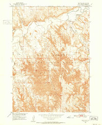
(10)- 1950 Map of Sheep Mountain Table, 1952 Print
 1950 Sheep Mountain Table1952 Print · USGSThe South Dakota badlands meet the Pine Ridge Indian Reservation in the early fifties, revealing a landscape of high mesas and deep-cut creeks. Researchers can trace the geological boundaries of Sheep Mountain Table or locate local landmarks like Cedar Butte and Heck Table.7 unique versions available
 - 1950 Map of Stirk Table, 1952 Print
 1950 Stirk Table1952 Print · USGSThe Pine Ridge Indian Reservation is shown here at mid-century, just as development for the Missouri River Basin was underway. Researchers can trace the rugged plateaus of Stirk Table and Cuny Table down to the banks of the White River.3 unique versions available
 - 1950 Map of Imlay SW, 1952 Print
 1950 Imlay SW1952 Print · USGSThe Pine Ridge Indian Reservation is captured at mid-century, showing the winding White River and the complex drainage of the High Plains. Researchers can locate the St Mary Magdalene Cem and trace seasonal watercourses like Big Hollow Creek and Spring Creek.3 unique versions available
 - 1950 Map of Imlay, 1952 Print
 1950 Imlay1952 Print · USGSPennington County at the midpoint of the twentieth century shows a landscape divided by federal land designations and the steam-and-diesel era. Trace the path of the Chicago Milwaukee St Paul and Pacific through Imlay or the northern reaches of the Pine Ridge Indian Reservation.3 unique versions available
 - 1950 Map of Imlay SE, 1952 Print
 1950 Imlay SE1952 Print · USGSThe Pine Ridge Indian Reservation is documented here in the early fifties, showing the winding path of the White River. Researchers can trace the location of St Barbaras Ch and various watercourses like Medicine Root Creek and Clifford Creek.2 unique versions available
 - 1950 Map of Bouquet Table, 1972 Print
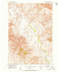
 1950 Bouquet Table1972 Print · USGSThe South Dakota badlands and the Pine Ridge Indian Reservation meet during the mid-twentieth century on this detailed survey. Genealogists and historians can trace local landmarks like the Cain Creek Sch and the route of the Chicago Milwaukee St Paul and Pacific railroad.
 - 1951 Map of Sharps Corner, 1953 Print
 1951 Sharps Corner1953 Print · USGSThe Pine Ridge Indian Reservation in the early fifties reveals a landscape of winding creek beds and remote community landmarks. Genealogists and local historians can trace the positions of Rockyford Ch, Gull Sch, and the road junction at Sharps Corner.2 unique versions available
 - 1951 Map of Rockyford, 1953 Print
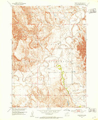 1951 Rockyford1953 Print · USGSThe Pine Ridge Indian Reservation during the early fifties reveals a landscape of high tablelands and winding river valleys. Genealogists and historians can trace the locations of rural community hubs like Rockyford, Steele Sch, and St Peter Ch.3 unique versions available
 - 1952 Map of Bouquet Table
 1952 Bouquet Table1952 Print · USGSThe border between the Pine Ridge Indian Reservation and Badlands National Monument is captured here in the early 1950s. Trace local landmarks like the Cain Creek Sch and the Chicago Milwaukee St Paul and Pacific rail line.
 - 1955 Map of Hot Springs, 1958 Print
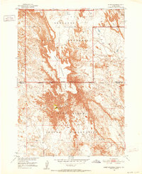
 1955 Hot Springs1958 Print · USGSThe Black Hills and South Dakota badlands are captured here in the mid-fifties, during a peak of military and industrial activity. Researchers can locate the Black Hills Ordnance Depot, early Uranium Mines, and historic rail stops like Pringle or Oglala.5 unique versions available
End of results
Showing maps 1-10 of 10
Top neighborhoods of Porcupine
Frequently asked questions
- What are the different types of historical maps available for Porcupine?
- What is the oldest map of Porcupine?
- Where can I purchase historical maps of Porcupine for my home or office?
- Where can I download high-res historical maps of Porcupine?
- Are there historical topographic maps available for Porcupine?
- Is there historical aerial imagery available for Porcupine?
- Where are historical maps of Porcupine sourced from?