1960s Maps of Selby, South Dakota
Explore 2 historic maps of Selby from the 1960s. These maps offer a rare glimpse into what life looked like during the 1960s — showing old roads, neighborhoods, homes, and landmarks that have changed or disappeared over time.
Whether you're researching your family's past, planning a metal detecting trip, or studying how Selby's landscape evolved across the 1960s, these high-resolution maps are a powerful tool for exploring the history of this region.
- Focus on a specific era: All maps on this page are from the 1960s, giving you a focused view of this time period.
- See what’s changed: Compare century-old streets, trails, and buildings to today's modern landscape using overlays and satellite layers.
- Research with precision: Use these maps for genealogy, historical research, land use analysis, or educational projects.
- View, download, or print: Maps are fully viewable online in high resolution, and can be downloaded or printed for your own records.
Start exploring Selby's history through authentic maps from the 1960s. This is your window into the past.
Selby, SD maps
(2)- 1967 Map of Selby, 1969 Print
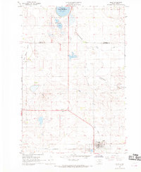 1967 Selby1969 Print · USGSWalworth and Campbell Counties show their agricultural and rail roots in the late sixties. Genealogists and local historians can trace the foundations of the community through sites like Bethany Cemetery, Monroe School, and the Selby rail corridor.
 - 1968 Map of Akaska NE, 1971 Print
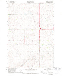 1968 Akaska NE1971 Print · USGSWalworth County settlement and rural infrastructure are captured here in the late sixties as the area around Selby continued to develop. Researchers can locate family sites and local landmarks like Selby Union Cem, Bangor Cem, and the Rabenberg Airport.
End of results
Showing maps 1-2 of 2
Top cities near Selby
Frequently asked questions
- What are the different types of historical maps available for Selby?
- What is the oldest map of Selby?
- Where can I purchase historical maps of Selby for my home or office?
- Where can I download high-res historical maps of Selby?
- Are there historical topographic maps available for Selby?
- Is there historical aerial imagery available for Selby?
- Where are historical maps of Selby sourced from?