1960s Maps of McLemoresville, Tennessee
Explore 2 historic maps of McLemoresville from the 1960s. These maps offer a rare glimpse into what life looked like during the 1960s — showing old roads, neighborhoods, homes, and landmarks that have changed or disappeared over time.
Whether you're researching your family's past, planning a metal detecting trip, or studying how McLemoresville's landscape evolved across the 1960s, these high-resolution maps are a powerful tool for exploring the history of this region.
- Focus on a specific era: All maps on this page are from the 1960s, giving you a focused view of this time period.
- See what’s changed: Compare century-old streets, trails, and buildings to today's modern landscape using overlays and satellite layers.
- Research with precision: Use these maps for genealogy, historical research, land use analysis, or educational projects.
- View, download, or print: Maps are fully viewable online in high resolution, and can be downloaded or printed for your own records.
Start exploring McLemoresville's history through authentic maps from the 1960s. This is your window into the past.
McLemoresville, TN maps
(2)- 1966 Map of Mc Lemoresville, 1967 Print
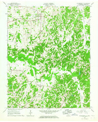 1966 Mc Lemoresville1967 Print · USGSCarroll County in the mid-sixties reveals a landscape of rural communities tied to the Rutherford Fork Obion River. Researchers can trace the Old Railroad Grade and locate family landmarks like Westview Sch and Cool Springs Cem.2 unique versions available
 - 1967 Map of Trezevant East, 1969 Print
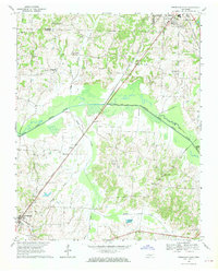 1967 Trezevant East1969 Print · USGSCarroll County in the late sixties reveals a landscape of river-bottom farms and rail-line settlements. Genealogists can trace local roots through St Johns Cem, New Zion, and family-named landmarks like Presely Lake.2 unique versions available
End of results
Showing maps 1-2 of 2
Top cities near McLemoresville
- McKenzie historical maps
- Huntingdon historical maps
- Greenfield historical maps
- Medina historical maps
- Gleason historical maps
- Bradford historical maps
See more
Frequently asked questions
- What are the different types of historical maps available for McLemoresville?
- What is the oldest map of McLemoresville?
- Where can I purchase historical maps of McLemoresville for my home or office?
- Where can I download high-res historical maps of McLemoresville?
- Are there historical topographic maps available for McLemoresville?
- Is there historical aerial imagery available for McLemoresville?
- Where are historical maps of McLemoresville sourced from?