2020s Maps of McLemoresville, Tennessee
Explore 2 historic maps of McLemoresville from the 2020s. These maps offer a rare glimpse into what life looked like during the 2020s — showing old roads, neighborhoods, homes, and landmarks that have changed or disappeared over time.
Whether you're researching your family's past, planning a metal detecting trip, or studying how McLemoresville's landscape evolved across the 2020s, these high-resolution maps are a powerful tool for exploring the history of this region.
- Focus on a specific era: All maps on this page are from the 2020s, giving you a focused view of this time period.
- See what’s changed: Compare century-old streets, trails, and buildings to today's modern landscape using overlays and satellite layers.
- Research with precision: Use these maps for genealogy, historical research, land use analysis, or educational projects.
- View, download, or print: Maps are fully viewable online in high resolution, and can be downloaded or printed for your own records.
Start exploring McLemoresville's history through authentic maps from the 2020s. This is your window into the past.
McLemoresville, TN maps
(2)- 2022 Map of Trezevant East, 2022 Print
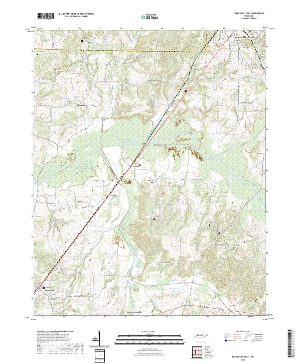 2022 Trezevant East2022 Print · USGSCarroll County is captured here in the early twenty-first century, showing the rural communities between Trezevant and McKenzie. Genealogists can locate numerous burial sites and small settlements, from Saint Johns Cem and New Zion to the quiet crossroads at Hinkledale.
 - 2022 Map of McLemoresville, 2022 Print
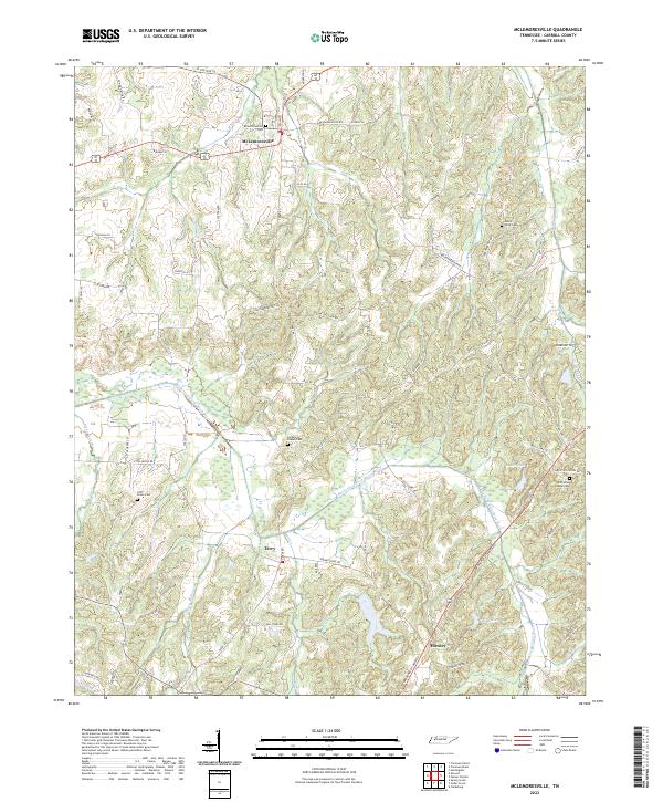 2022 McLemoresville2022 Print · USGSModern Carroll County retains its deep rural roots in this 2022 survey centered on the historic McLemoresville area. Researchers can locate several lineage-rich sites like Christian Chapel Cem, Little Grove Cem, and the path of the Rutherford Fork Obion River.
End of results
Showing maps 1-2 of 2
Top cities near McLemoresville
- McKenzie historical maps
- Huntingdon historical maps
- Greenfield historical maps
- Medina historical maps
- Gleason historical maps
- Bradford historical maps
See more
Frequently asked questions
- What are the different types of historical maps available for McLemoresville?
- What is the oldest map of McLemoresville?
- Where can I purchase historical maps of McLemoresville for my home or office?
- Where can I download high-res historical maps of McLemoresville?
- Are there historical topographic maps available for McLemoresville?
- Is there historical aerial imagery available for McLemoresville?
- Where are historical maps of McLemoresville sourced from?