1940s Maps of Fairfield Glade, Tennessee
Explore 8 historic maps of Fairfield Glade from the 1940s. These maps offer a rare glimpse into what life looked like during the 1940s — showing old roads, neighborhoods, homes, and landmarks that have changed or disappeared over time.
Whether you're researching your family's past, planning a metal detecting trip, or studying how Fairfield Glade's landscape evolved across the 1940s, these high-resolution maps are a powerful tool for exploring the history of this region.
- Focus on a specific era: All maps on this page are from the 1940s, giving you a focused view of this time period.
- See what’s changed: Compare century-old streets, trails, and buildings to today's modern landscape using overlays and satellite layers.
- Research with precision: Use these maps for genealogy, historical research, land use analysis, or educational projects.
- View, download, or print: Maps are fully viewable online in high resolution, and can be downloaded or printed for your own records.
Start exploring Fairfield Glade's history through authentic maps from the 1940s. This is your window into the past.
Fairfield Glade, TN maps
(8)- 1943 Map of Hebbertsburg, 1957 Print
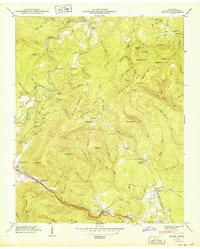
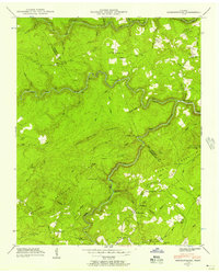 1943 Hebbertsburg1957 Print · USGSThe Cumberland Plateau landscape near the Morgan and Cumberland county line comes to life in the 1940s. Genealogists and local historians can trace the foundations of mountain life through Frankfort, the New Home Church, and old river crossings like Potter Ford.5 unique versions available
 - 1945 Map of Hebbertsburg
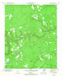
 1945 Hebbertsburg1945 Print · USGSCumberland and Morgan counties appear here in the mid-1940s, where river fords and mountain ridges dictated the pace of rural life. Genealogists and local historians can locate old landmarks like Potter Chapel Sch, Hebbertsburg, and the Pilot Knob Lookout Tower.
 - 1946 Map of Fox Creek, 1968 Print
 1946 Fox Creek1968 Print · USGSCumberland County rural life is captured here in the mid-1940s, centered on the deep gorge of the Obed River. Researchers can trace family sites like Henry Cem, early schools including Slate Springs Sch, and the remote Elmore Gem mine.3 unique versions available
 - 1946 Map of Dorton, 1971 Print
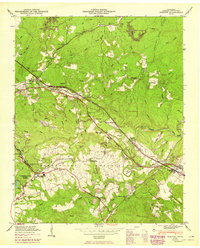
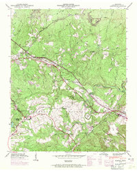 1946 Dorton1971 Print · USGSCumberland County during the post-war era showcases the fascinating New Deal planning of the Cumberland Homesteads. Genealogists and historians can trace family locations near the Homestead Cem, Baker Chapel, and the tracks of the Tennessee Central railroad.2 unique versions available
 - 1946 Map of Ozone, 1975 Print
 1946 Ozone1975 Print · USGSCumberland County settlement and transport patterns are captured here as the new interstate began to reshape the plateau during the mid-sixties. Genealogists and local historians can trace legacy sites from Ozone to Crab Orchard, including Glade Cem, Old Walton Road, and the Tennessee Central railroad line.2 unique versions available
 - 1949 Map of Ozone
 1949 Ozone1949 Print · USGSCumberland County’s mountain gaps and plateau settlements are captured here in the late 1940s, just as modern highways began to parallel historic pioneer trails. Researchers can trace the path of the Old Walton Road and locate family burial sites like Gill Cem and Millstone Cem.2 unique versions available
 - 1949 Map of Fox Creek
 1949 Fox Creek1949 Print · USGSCumberland County’s high plateau country is shown here in the late Forties as a landscape of isolated homesteads and deep river gorges. Genealogists can locate family landmarks like Henry Cem and Elmore Cem or trace old routes to Genesis and the Potter Ford.
 - 1949 Map of Dorton
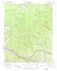
 1949 Dorton1949 Print · USGSCumberland County’s plateau landscape is captured here in the mid-century during the development of the Tennessee Central Railroad. Researchers can locate family sites at Turner Cem and Homestead Cem, or trace early community hubs like Dorton Sch and Baker Chapel.2 unique versions available
End of results
Showing maps 1-8 of 8
Top cities near Fairfield Glade
- Crossville historical maps
- Rockwood historical maps
- Crab Orchard historical maps
- Sunbright historical maps
Top neighborhoods of Fairfield Glade
- Dochester historical maps
- Lake Pomeroy historical maps
- Windsor Bluff historical maps
- Peavine historical maps
- Berkshire Forest historical maps
- Wiltshire historical maps
See more
Frequently asked questions
- What are the different types of historical maps available for Fairfield Glade?
- What is the oldest map of Fairfield Glade?
- Where can I purchase historical maps of Fairfield Glade for my home or office?
- Where can I download high-res historical maps of Fairfield Glade?
- Are there historical topographic maps available for Fairfield Glade?
- Is there historical aerial imagery available for Fairfield Glade?
- Where are historical maps of Fairfield Glade sourced from?