1960s Maps of Franklin County, Tennessee
Explore 9 historic maps of Franklin County from the 1960s. These maps offer a rare glimpse into what life looked like during the 1960s — showing old roads, neighborhoods, homes, and landmarks that have changed or disappeared over time.
Whether you're researching your family's past, planning a metal detecting trip, or studying how Franklin County's landscape evolved across the 1960s, these high-resolution maps are a powerful tool for exploring the history of this region.
- Focus on a specific era: All maps on this page are from the 1960s, giving you a focused view of this time period.
- See what’s changed: Compare century-old streets, trails, and buildings to today's modern landscape using overlays and satellite layers.
- Research with precision: Use these maps for genealogy, historical research, land use analysis, or educational projects.
- View, download, or print: Maps are fully viewable online in high resolution, and can be downloaded or printed for your own records.
Start exploring Franklin County's history through authentic maps from the 1960s. This is your window into the past.
Franklin County, TN maps
(9)- 1960 Map of Gadsden
 1960 Gadsden1960 Print · USGSNorthern Alabama in the mid-1950s is defined by the mighty Tennessee River and its massive reservoirs. Trace the development of Huntsville and Redstone Arsenal or explore the vast William B Bankhead National Forest.2 unique versions available
 - 1960 Map of Chattanooga
 1960 Chattanooga1960 Print · USGSSoutheast Tennessee and the southern Appalachians are shown here at the height of the river-management era. You can trace the valley rail lines and locate Lookout Mountain and the expansive waters of Chickamauga Reservoir.
 - 1961 Map of Rome
 1961 Rome1961 Print · USGSNorthwest Georgia and neighboring Tennessee and Alabama are shown here at a moment of significant mid-century growth. Researchers can trace the rail networks of the Central of Georgia or locate landmarks within Chickamauga and Chattanooga Nat Military Park.
 - 1962 Map of Capitol Hill, 1964 Print
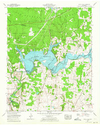 1962 Capitol Hill1964 Print · USGSFranklin and Coffee counties are shown here in the early sixties as military engineering and lake recreation transformed the Elk River valley. Trace the impact of the Woods Reservoir on local landmarks like Morris Ferry Bridge and the Arnold Engineering Development Center.
 - 1962 Map of Tullahoma, 1965 Print
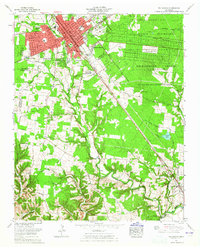 1962 Tullahoma1965 Print · USGSTullahoma and Estill Springs are captured in the early sixties during a period of significant military and aerospace activity. Researchers can trace the sprawling Arnold Engineering Development Center or find family landmarks like Oakwood Cem and East Lincoln Sch.
 - 1963 Map of Rome
 1963 Rome1963 Print · USGSThe tri-state corner of Georgia, Alabama, and Tennessee is captured here during a period of massive reservoir expansion and post-war growth. Genealogists and historians can trace the rail corridors of the Southern Ry or locate landmarks like Fort Oglethorpe and Cloudland Canyon State Park.
 - 1963 Map of Gadsden
 1963 Gadsden1963 Print · USGSNorthern Alabama underwent a dramatic mid-century transformation as the Tennessee Valley became a hub for defense and industry. Researchers can trace the development of the Redstone Arsenal, the route of the Natchez Trace Parkway, and long-standing rail lines like the Southern Railway.
 - 1964 Map of Chattanooga
 1964 Chattanooga1964 Print · USGSSoutheast Tennessee and the western Carolinas appear in the mid-sixties as a powerhouse of river-driven industry and mountain wilderness. Genealogists and historians can trace rail-town lineages along the Southern Ry or locate family landmarks near Watts Bar Lake and Tellico Plains.
 - 1967 Map of Doran Cove, 1972 Print
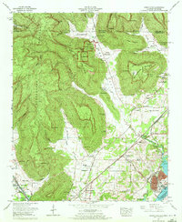 1967 Doran Cove1972 Print · USGSThe Alabama-Tennessee borderlands appear here in the late sixties, where the Cumberland Plateau gives way to river-valley industry. Genealogists can trace family ties at Hackworth Cem, Walker Cem, and the historic Russell Cave National Monument.4 unique versions available
End of results
Showing maps 1-9 of 9
Top cities of Franklin County
- Winchester historical maps
- Sewanee historical maps
- Estill Springs historical maps
- Decherd historical maps
- Cowan historical maps
- Huntland historical maps
Frequently asked questions
- What are the different types of historical maps available for Franklin County?
- What is the oldest map of Franklin County?
- Where can I purchase historical maps of Franklin County for my home or office?
- Where can I download high-res historical maps of Franklin County?
- Are there historical topographic maps available for Franklin County?
- Is there historical aerial imagery available for Franklin County?
- Where are historical maps of Franklin County sourced from?