1930s Maps of Minor Hill, Tennessee
Explore 4 historic maps of Minor Hill from the 1930s. These maps offer a rare glimpse into what life looked like during the 1930s — showing old roads, neighborhoods, homes, and landmarks that have changed or disappeared over time.
Whether you're researching your family's past, planning a metal detecting trip, or studying how Minor Hill's landscape evolved across the 1930s, these high-resolution maps are a powerful tool for exploring the history of this region.
- Focus on a specific era: All maps on this page are from the 1930s, giving you a focused view of this time period.
- See what’s changed: Compare century-old streets, trails, and buildings to today's modern landscape using overlays and satellite layers.
- Research with precision: Use these maps for genealogy, historical research, land use analysis, or educational projects.
- View, download, or print: Maps are fully viewable online in high resolution, and can be downloaded or printed for your own records.
Start exploring Minor Hill's history through authentic maps from the 1930s. This is your window into the past.
Minor Hill, TN maps
(4)- 1936 Map of Union Hill
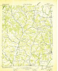
 1936 Union Hill1936 Print · USGSThe Alabama and Tennessee borderlands are captured here in the mid-1930s as modern infrastructure arrived in a landscape of small family farms. Researchers can locate long-standing landmarks like Ridgeways Mill, Hester Cem, and the rural community of Good Springs.
 - 1936 Map of Aspen Hill
 1936 Aspen Hill1936 Print · USGSGiles County at the mid-thirties is a landscape of rural schoolhouses and family-named hollows connected by the Louisville and Nashville Railroad. You can trace the historic footprint of Aspen Hill and find lost landmarks like Tarpleys Store or Beasley Chapel School.
 - 1936 Map of Appleton
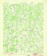 1936 Appleton1936 Print · USGSGiles and Lawrence Counties are captured here in the mid-1930s, showing a rural landscape of creek-side settlements and family homesteads. Researchers can trace ancestral locations through numerous sites like Powell Cem, Appleton Sch, and Minor Hill.
 - 1936 Map of Salem
 1936 Salem1936 Print · USGSNorthern Alabama in the mid-thirties shows a landscape being reshaped by the rising waters of Wheeler Reservoir. Genealogists can trace early homesteads and family sites like Conniegun Cem and Walnut Grove Ch.
End of results
Showing maps 1-4 of 4
Top cities near Minor Hill
- Huntsville historical maps
- Athens historical maps
- Lawrenceburg historical maps
- Pulaski historical maps
- Rogersville historical maps
- Lexington historical maps
See more
Frequently asked questions
- What are the different types of historical maps available for Minor Hill?
- What is the oldest map of Minor Hill?
- Where can I purchase historical maps of Minor Hill for my home or office?
- Where can I download high-res historical maps of Minor Hill?
- Are there historical topographic maps available for Minor Hill?
- Is there historical aerial imagery available for Minor Hill?
- Where are historical maps of Minor Hill sourced from?