
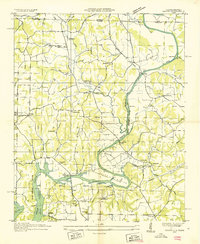
1936 Map of Appleton
USGS Topo · Published 1936About this map
The hills of southern Tennessee along the Lawrence and Giles county line are defined by a dense network of creek forks and family-named hollows. Settlements like Minor Hill and Appleton serve as central nodes for a landscape dotted with small rural institutions. Local education and faith are anchored at sites such as Liberty Hill Sch, Puncheon Ch, and Appleton Ch, while commercial life is represented by Williams Store and Bullington Store.
Find a feature on this map
75 named features on this map. Tap any name to fly to it.
Don’t see what you’re looking for? This feature index may not catch every label — zoom into the map to look around manually.
Map Details
Editions of this 1936 Appleton Map
This is the sole edition of this map. No revisions or reprints were ever made.
Other maps of this area

1914 · Rogersville
USGS Topo · 1:48,000

1916 · Rogersville
USGS Topo · 1:62,500

1936 · Union Hill
USGS Topo · 1:24,000

1936 · Aspen Hill
USGS Topo · 1:24,000

1936 · Lexington
USGS Topo · 1:24,000

1936 · Lawrenceburg
USGS Topo · 1:24,000

1936 · Pulaski
USGS Topo · 1:24,000

1936 · Bodenham
USGS Topo · 1:24,000

1936 · Bonnertown
USGS Topo · 1:24,000
1936 · Salem
USGS Topo · 1:24,000