1940s Maps of Falling Water, Tennessee
Explore 2 historic maps of Falling Water from the 1940s. These maps offer a rare glimpse into what life looked like during the 1940s — showing old roads, neighborhoods, homes, and landmarks that have changed or disappeared over time.
Whether you're researching your family's past, planning a metal detecting trip, or studying how Falling Water's landscape evolved across the 1940s, these high-resolution maps are a powerful tool for exploring the history of this region.
- Focus on a specific era: All maps on this page are from the 1940s, giving you a focused view of this time period.
- See what’s changed: Compare century-old streets, trails, and buildings to today's modern landscape using overlays and satellite layers.
- Research with precision: Use these maps for genealogy, historical research, land use analysis, or educational projects.
- View, download, or print: Maps are fully viewable online in high resolution, and can be downloaded or printed for your own records.
Start exploring Falling Water's history through authentic maps from the 1940s. This is your window into the past.
Falling Water, TN maps
(2)- 1945 Map of Fairmount, 1957 Print
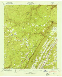 1945 Fairmount1957 Print · USGSThe Cumberland Plateau meets the valley floor north of Chattanooga in the mid-1940s. Local researchers can trace family landmarks along Sawyer Road and locate rural hubs like Lone Oak, Summertown, and the Nathan L Bachman Sch.
 - 1946 Map of Fairmount, 1947 Print
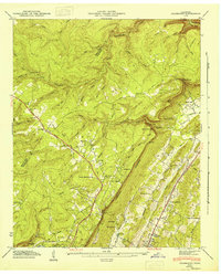 1946 Fairmount1947 Print · USGSHamilton County uplands and the plateau settlements north of Chattanooga are captured here just after the war. Genealogists can locate family landmarks like Vandergriff Cem and Levi Cem or trace rural routes like the William Howard Taft Highway.
End of results
Showing maps 1-2 of 2
Top cities near Falling Water
- Chattanooga historical maps
- East Ridge historical maps
- East Ridge historical maps
- Soddy-Daisy historical maps
- Fort Oglethorpe historical maps
- Collegedale historical maps
See more
Frequently asked questions
- What are the different types of historical maps available for Falling Water?
- What is the oldest map of Falling Water?
- Where can I purchase historical maps of Falling Water for my home or office?
- Where can I download high-res historical maps of Falling Water?
- Are there historical topographic maps available for Falling Water?
- Is there historical aerial imagery available for Falling Water?
- Where are historical maps of Falling Water sourced from?