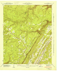
1946 Map of Fairmount
USGS Topo · Published 1947About this map
The Cumberland Escarpment dominates the topography of this Hamilton County landscape as it appeared in the mid-1940s. Transportation through the high plateaus is anchored by the William Howard Taft Highway, which links settlements like Lone Oak and Fairmount across the upland terrain. This era of rural Tennessee life is marked by a network of local institutions, including the Nathan L Bachman Sch and Mt View Ch, alongside numerous family burial grounds such as the Vandergriff Cem and Levi Cem. The natural drainage of the region is defined by deep cuts like Chickamauga Gulch and the dramatic drop of Falling Water Falls. In the south, the development around Signal Mountain and its Golf Course signals a transition toward more suburbanized patterns near Red Bank.
Find a feature on this map
62 named features on this map. Tap any name to fly to it.
Don’t see what you’re looking for? This feature index may not catch every label — zoom into the map to look around manually.
Map Details
Editions of this 1946 Fairmount Map
This is the sole edition of this map. No revisions or reprints were ever made.
Other maps of this area

1888 · Chattanooga
USGS Topo · 1:125,000

1893 · Chattanooga
USGS Topo · 1:125,000

1935 · East Chattanooga
USGS Topo · 1:24,000

1935 · Daisy
USGS Topo · 1:24,000

1935 · Soddy
USGS Topo · 1:24,000

1936 · Daus
USGS Topo · 1:24,000

1936 · Henson Gap
USGS Topo · 1:24,000

1936 · Ketner Gap
USGS Topo · 1:24,000

1936 · Fairmount
USGS Topo · 1:24,000

1936 · Wauhatchie
USGS Topo · 1:24,000