1940s Maps of Hawkins County, Tennessee
Explore 14 historic maps of Hawkins County from the 1940s. These maps offer a rare glimpse into what life looked like during the 1940s — showing old roads, neighborhoods, homes, and landmarks that have changed or disappeared over time.
Whether you're researching your family's past, planning a metal detecting trip, or studying how Hawkins County's landscape evolved across the 1940s, these high-resolution maps are a powerful tool for exploring the history of this region.
- Focus on a specific era: All maps on this page are from the 1940s, giving you a focused view of this time period.
- See what’s changed: Compare century-old streets, trails, and buildings to today's modern landscape using overlays and satellite layers.
- Research with precision: Use these maps for genealogy, historical research, land use analysis, or educational projects.
- View, download, or print: Maps are fully viewable online in high resolution, and can be downloaded or printed for your own records.
Start exploring Hawkins County's history through authentic maps from the 1940s. This is your window into the past.
Hawkins County, TN maps
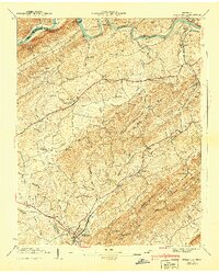
(14)- 1940 Map of Stony Point
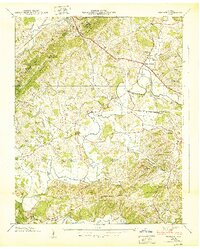
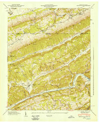
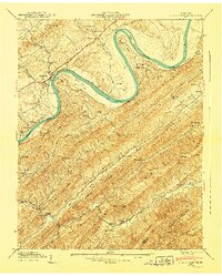 1940 Stony Point1940 Print · USGSHawkins County is captured here just before the mid-century, where the winding Holston River meets a landscape of steep mountain ridges and fertile valley bottoms. Genealogists and local historians can locate Surgoinsville, trace the old Southern Railroad, and find rural landmarks like Mowls Mill and Maxwell Academy.
 - 1940 Map of Lee Valley
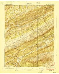 1940 Lee Valley1940 Print · USGSHawkins and Hancock Counties appear here at the start of the 1940s, showing a landscape defined by the ridgelines of Clinch Mountain. Local historians can trace old homesteads and community hubs like Lee Valley, Fairmont Sch, and the Morrell Cem.
 - 1940 Map of Baileyton
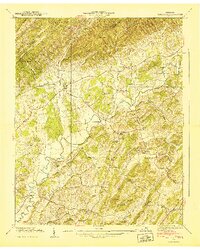 1940 Baileyton1940 Print · USGSGreene County agriculture and mountain life are captured here just before the mid-century, showing the tightly-knit network of mills and valley schools. Researchers can trace family sites near Lick Creek Mill, Wesley Chapel, and Brittontown Sch.
 - 1940 Map of Burem
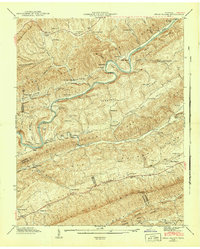
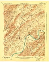 1940 Burem1940 Print · USGSHawkins County, Tennessee, is captured here just before the 1940s, showing a river-carved landscape of ridges and rural settlements. Genealogists and local historians can trace family locations through Alumwell Academy, Hennard Mill, and the Ebbing and Flowing Spring.2 unique versions available
 - 1940 Map of Mohawk
 1940 Mohawk1940 Print · USGSEast Tennessee at the dawn of the 1940s reveals a landscape of tight-knit rural communities connected by the SOUTHERN railroad. Genealogists can locate family landmarks like Darrow Mill, Crosby Cem, and several local schoolhouses like Salem Sch.
 - 1940 Map of Mc Cloud
 1940 Mc Cloud1940 Print · USGSJust before the mid-century, this corner of East Tennessee shows a landscape defined by the Bays Mountains and rural agriculture. Genealogists can trace family names at Patterson Cem or locate community hubs like Romeo and Bandy Chapel.
 - 1940 Map of Russellville
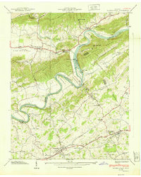 1940 Russellville1940 Print · USGSHamblen and Hawkins Counties come alive in this pre-war survey of the Holston River valley. Genealogists and historians can trace the foundations of Russellville and Whitesburg, locating family-named sites like Hyatt Cem and the Cain Mill.
 - 1940 Map of Pressmens Home
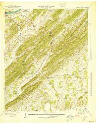
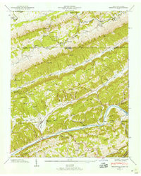
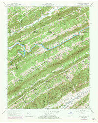
 1940 Pressmens Home1940 Print · USGSHawkins County is seen here at the dawn of the 1940s, defined by the high ridges of Stone Mountain and the winding Holston River. Researchers can locate historic sites like Pressmens Home, Austins Mill, and the mountain passage of the Trail of the Lonesome Pine.2 unique versions available
 - 1940 Map of Bulls Gap
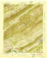
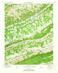
 1940 Bulls Gap1940 Print · USGSBulls Gap and the Hawkins County countryside are captured here just before the 1940s, showing a landscape defined by the Southern railroad and river life. Genealogists can trace family names across dozens of sites like Mcbride Cem, Austins Mill, and the Price Ferry on the Holston River.2 unique versions available
 - 1941 Map of Swan Island, 1965 Print
 1941 Swan Island1965 Print · USGSHancock County in the early 1940s is captured in this survey of the river-carved ridges along the Clinch River. Researchers can locate dozens of family landmarks, from Lawson Mill and Manning Ferry to the Barnard Cem and Williams Cem.2 unique versions available
 - 1942 Map of Swan Island
 1942 Swan Island1942 Print · USGSThe ridges of East Tennessee meet the winding Clinch River during the early 1940s, a time when ferries and mills still served rural Hancock and Grainger counties. Genealogists can trace family roots through numerous sites like Barnard Cem, Lawson Mill, and Manning Ferry.
 - 1946 Map of Sneedville, 1958 Print
 1946 Sneedville1958 Print · USGSHancock County and the Clinch River valley are shown here in the mid-1940s, a time when mountain gaps and river fords still shaped local life. Genealogists can trace family heritage through dozens of named sites like Vanderventer Cem, Thompson Mill, and Vardy Community Sch.3 unique versions available
 - 1947 Map of Sneedville, 1949 Print
 1947 Sneedville1949 Print · USGSHancock County is mapped here in the late 1940s as a landscape of tight-knit river communities and high mountain ridges. Genealogists can trace family names at Vanderventer Cem and Goins Cem or locate rural landmarks like Thompson Mill.
 - 1947 Map of Looneys Gap, 1970 Print
 1947 Looneys Gap1970 Print · USGSThe Clinch River valley in the late 1940s and late 1960s reveals a landscape of isolated ridge-and-valley settlements straddling the Virginia and Tennessee border. Researchers can trace ancestral locations at the County Farm, the Wake Forest School, and family plots like Sizemore Cem.
End of results
Showing maps 1-14 of 14
Top cities of Hawkins County
- Church Hill historical maps
- Rogersville historical maps
- Surgoinsville historical maps
- Mooresburg historical maps
- Bulls Gap historical maps
Frequently asked questions
- What are the different types of historical maps available for Hawkins County?
- What is the oldest map of Hawkins County?
- Where can I purchase historical maps of Hawkins County for my home or office?
- Where can I download high-res historical maps of Hawkins County?
- Are there historical topographic maps available for Hawkins County?
- Is there historical aerial imagery available for Hawkins County?
- Where are historical maps of Hawkins County sourced from?