1960s Maps of Hawkins County, Tennessee
Explore 9 historic maps of Hawkins County from the 1960s. These maps offer a rare glimpse into what life looked like during the 1960s — showing old roads, neighborhoods, homes, and landmarks that have changed or disappeared over time.
Whether you're researching your family's past, planning a metal detecting trip, or studying how Hawkins County's landscape evolved across the 1960s, these high-resolution maps are a powerful tool for exploring the history of this region.
- Focus on a specific era: All maps on this page are from the 1960s, giving you a focused view of this time period.
- See what’s changed: Compare century-old streets, trails, and buildings to today's modern landscape using overlays and satellite layers.
- Research with precision: Use these maps for genealogy, historical research, land use analysis, or educational projects.
- View, download, or print: Maps are fully viewable online in high resolution, and can be downloaded or printed for your own records.
Start exploring Hawkins County's history through authentic maps from the 1960s. This is your window into the past.
Hawkins County, TN maps
(9)- 1960 Map of Johnson City
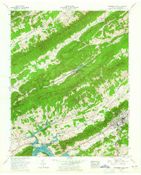
 1960 Johnson City1960 Print · USGSUpper East Tennessee and the surrounding tri-state area are shown in the mid-fifties during the height of the TVA reservoir era. Trace the industrial rail lines of the Southern and Louisville and Nashville between Kingsport and Johnson City.
 - 1960 Map of Bean Station, 1962 Print
 1960 Bean Station1962 Print · USGSBean Station and the surrounding ridges of Grainger County are shown here at a time when the impounded waters of the Holston River had reshaped the local economy. Researchers can locate family landmarks like Barnards Grove Ch Cem or trace the early paths of the Dixie Highway and Lee Highway.3 unique versions available
 - 1961 Map of Russellville, 1962 Print
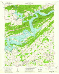 1961 Russellville1962 Print · USGSNortheastern Tennessee's river valleys and ridges are captured here in the early sixties as the sprawling waters of Cherokee Lake reshaped the landscape. Researchers can locate historic sites like Cain Mill, the Southern Railroad line through Whitesburg, and numerous family plots including Gladson Cem and Hyatt Cem.3 unique versions available
 - 1961 Map of Burem, 1964 Print
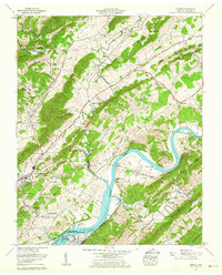 1961 Burem1964 Print · USGSThe Holston River valley in the early 1960s reveals a blend of traditional Appalachian farmsteads and modern energy infrastructure. Researchers can locate family cemeteries like Klepper Cem, the historic Henard Mill, and the rail-side community of Burem.3 unique versions available
 - 1961 Map of Mc Cloud, 1965 Print
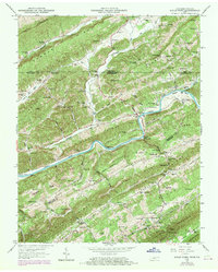
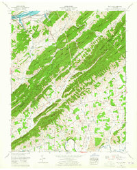 1961 Mc Cloud1965 Print · USGSThe Hawkins and Greene County line follows the high ridges of the Bays Mountains in the early sixties. Researchers can trace rural life through the Romeo Sch, family landmarks like Kite Cem, and the industrial John Sevier Steam Plant near the river.2 unique versions available
 - 1961 Map of Pressmens Home, 1965 Print
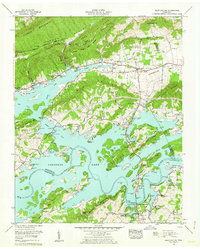
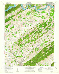
 1961 Pressmens Home1965 Print · USGSHawkins County is captured here in the early sixties, showing the unique union headquarters at Pressmens Home and the rising waters of Cherokee Lake. Local researchers can trace family roots at Starnes Cem, Klepper Chapel, and Maple Hill Sch.2 unique versions available
 - 1962 Map of Bulls Gap, 1964 Print
 1962 Bulls Gap1964 Print · USGSEast Tennessee life in the early sixties centers on the rail hub of Bulls Gap and the rising waters of Cherokee Lake. Genealogists can trace family footprints through dozens of sites like Price Cem, Austins Mill, and Liberty Hill Church.2 unique versions available
 - 1963 Map of Johnson City
 1963 Johnson City1963 Print · USGSThe Tri-Cities and the surrounding Appalachian ridges are shown in detail during the early sixties, highlighting the era's vital rail and river networks. Genealogists and historians can trace the routes of the Clinchfield RR and locate settlements from Rogersville to Elizabethton.
 - 1969 Map of Kyles Ford, 1970 Print
 1969 Kyles Ford1970 Print · USGSThe Clinch River borderlands of Tennessee and Virginia appear here in the late sixties, showing a landscape defined by deep ridges and isolated valleys. Genealogists can locate family landmarks like Pridemore Cem and historic community hubs such as Livesay Mill and the Lonesome Pine School.
End of results
Showing maps 1-9 of 9
Top cities of Hawkins County
- Church Hill historical maps
- Rogersville historical maps
- Surgoinsville historical maps
- Mooresburg historical maps
- Bulls Gap historical maps
Frequently asked questions
- What are the different types of historical maps available for Hawkins County?
- What is the oldest map of Hawkins County?
- Where can I purchase historical maps of Hawkins County for my home or office?
- Where can I download high-res historical maps of Hawkins County?
- Are there historical topographic maps available for Hawkins County?
- Is there historical aerial imagery available for Hawkins County?
- Where are historical maps of Hawkins County sourced from?