1960s Maps of Haywood County, Tennessee
Explore 9 historic maps of Haywood County from the 1960s. These maps offer a rare glimpse into what life looked like during the 1960s — showing old roads, neighborhoods, homes, and landmarks that have changed or disappeared over time.
Whether you're researching your family's past, planning a metal detecting trip, or studying how Haywood County's landscape evolved across the 1960s, these high-resolution maps are a powerful tool for exploring the history of this region.
- Focus on a specific era: All maps on this page are from the 1960s, giving you a focused view of this time period.
- See what’s changed: Compare century-old streets, trails, and buildings to today's modern landscape using overlays and satellite layers.
- Research with precision: Use these maps for genealogy, historical research, land use analysis, or educational projects.
- View, download, or print: Maps are fully viewable online in high resolution, and can be downloaded or printed for your own records.
Start exploring Haywood County's history through authentic maps from the 1960s. This is your window into the past.
Haywood County, TN maps
(9)- 1961 Map of Jones, 1963 Print
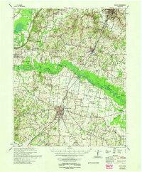
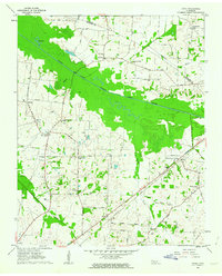 1961 Jones1963 Print · USGSHaywood and Crockett counties are captured here in the early sixties, a landscape defined by the winding South Fork Forked Deer River. Family researchers can trace ancestral locations near Owl City, Wortham Chapel Cemetery, and the Louisville and Nashville rail line.2 unique versions available
 - 1961 Map of Rialto, 1963 Print
 1961 Rialto1963 Print · USGSWest Tennessee in the early sixties was a landscape of river-bottom farms and interconnected parish life along the Hatchie River. Researchers can trace the heritage of Covington and Ripley, alongside rural landmarks like the Fort Pillow State Prison Farm and Plumer Grove Ch & Sch.
 - 1961 Map of Mercer, 1964 Print
 1961 Mercer1964 Print · USGSThe Hatchie River floodplain in the early sixties is a landscape of oxbow lakes and rail-side settlements. Researchers can trace family history at Hayes Chapel Cem, find the site of the Brown Sch, or locate the Old Ferry Landing.2 unique versions available
 - 1961 Map of Halls, 1965 Print
 1961 Halls1965 Print · USGSLauderdale and Dyer counties are shown in the early sixties as the West Tennessee landscape hummed with activity along the Illinois Central tracks. Researchers can trace rural lineages through dozens of named sites like Miller Chapel Cem, Benton Sch, and the U. S. Military Reservation.
 - 1962 Map of Rialto
 1962 Rialto1962 Print · USGSTipton and Lauderdale counties are mapped here in the early sixties, showing a landscape defined by the Hatchie River and the Illinois Central line. Genealogists can locate many local landmarks, including Rialto Ch & Sch, Canaan Cem, and the Fort Pillow State Prison Farm.
 - 1964 Map of Tibbs, 1965 Print
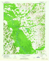
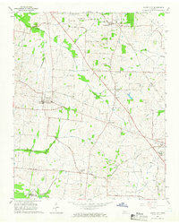
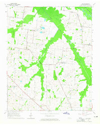 1964 Tibbs1965 Print · USGSHaywood County in the mid-sixties reveals a rural landscape of scattered hamlets and family-named schools before modern consolidation. Genealogists can trace the locations of Antioch Ch, Woodlawn Cem, and early educational sites like Hickory Grove Sch.2 unique versions available
 - 1964 Map of Turnpike, 1965 Print
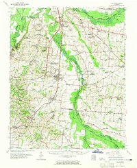
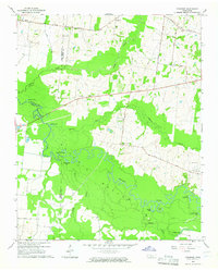 1964 Turnpike1965 Print · USGSThe Hatchie River lowlands of West Tennessee are captured here in the mid-sixties, showing a landscape defined by river bends and wetland basins. Researchers can locate vanished landmarks like New Hope School, Turnpike, and family sites such as Estes Cemetery and Walker School.2 unique versions available
 - 1964 Map of Durhamville, 1965 Print
 1964 Durhamville1965 Print · USGSThe West Tennessee borderlands of Haywood and Lauderdale counties are documented here in the mid-1960s. Genealogists and local historians can trace family locations near Durhamville, Nutbush, and landmarks such as St Pauls Ch or Holmes Cem.2 unique versions available
 - 1964 Map of Maury City, 1966 Print
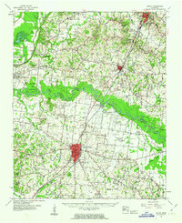
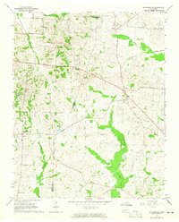
 1964 Maury City1966 Print · USGSCrockett County life in the mid-1960s is centered on rural crossroads and the rail line connecting Maury City to Alamo. Researchers can trace family history through a network of local landmarks like Hamlett Robertson Sch and the Pond Creek Cem.2 unique versions available
End of results
Showing maps 1-9 of 9
Top cities of Haywood County
Frequently asked questions
- What are the different types of historical maps available for Haywood County?
- What is the oldest map of Haywood County?
- Where can I purchase historical maps of Haywood County for my home or office?
- Where can I download high-res historical maps of Haywood County?
- Are there historical topographic maps available for Haywood County?
- Is there historical aerial imagery available for Haywood County?
- Where are historical maps of Haywood County sourced from?