Old Maps of Haywood County, Tennessee for Academic Research
Study the evolution of Haywood County with 111 high-resolution historic maps. Whether you're teaching, researching, or modeling changes in land use, these maps provide essential visual documentation of urban, environmental, and geographic change.
- Analyze long-term change: Track patterns in development, transportation, and natural features.
- Ideal for environmental or urban studies: Support academic projects with primary historical map data.
- Use in the classroom or lab: Educators and researchers rely on these maps to bring historical context to life.
These maps are a powerful tool for teaching, research, and visualizing how Haywood County has changed over the decades.
Haywood County, TN maps
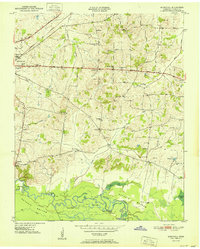
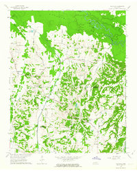
(111)- 1939 Map of Halls, 1943 Print
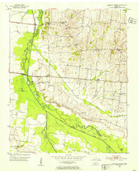
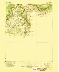 1939 Halls1943 Print · USGSLauderdale and Dyer Counties are mapped here during the late 1930s as the river-and-rail economy shaped West Tennessee life. Genealogists and researchers can trace the rural communities of Unionville, Fowlkes, and Key Corner, alongside landmark sites like Charles Chapel and the Nankipoo Sch.
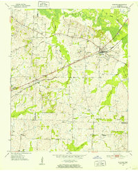
 - 1950 Map of Sunnyhill, 1981 Print
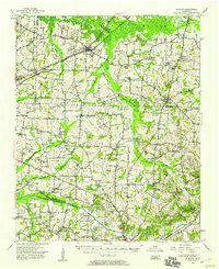
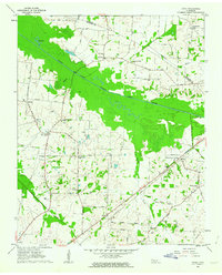
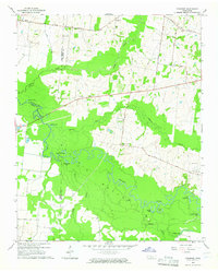
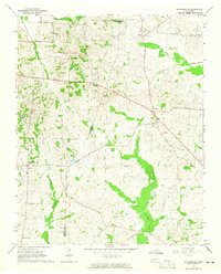
 1950 Sunnyhill1981 Print · USGSMid-century Haywood County comes into focus as the Hatchie River winds through the bottomlands. Genealogists can trace family connections at Beech Grove Cem and Rosenwald Cem or locate old school sites like Springfield Sch.2 unique versions available
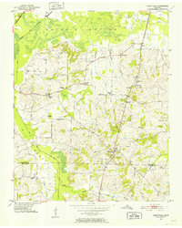
 - 1950 Map of Brownsville, 1983 Print
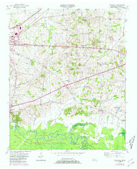
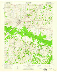
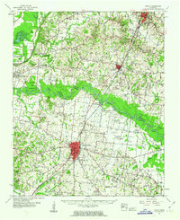
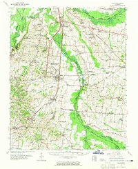
 1950 Brownsville1983 Print · USGSBrownsville and the surrounding Haywood County countryside appear here in the mid-twentieth century, featuring the town's growth and the river bottom's wetlands. Researchers can locate the SEABOARD rail line, rural landmarks like Cuthbert Switch, and the sprawling Hatchie National Wildlife Refuge.
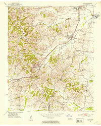
 - 1951 Map of Brownsville
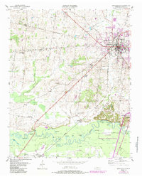
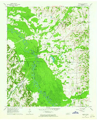
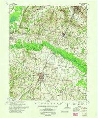
 1951 Brownsville1951 Print · USGSBrownsville was a thriving railroad hub and agricultural center in the early fifties, anchored by the Broadway of America. Genealogists can trace the rural landscape through Oakwood Cem, Shepp (Shepards Sta), and local schools like Cuthbert Switch Sch.3 unique versions available
 - 1951 Map of Sunnyhill
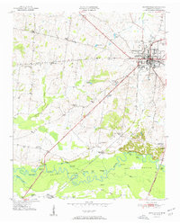
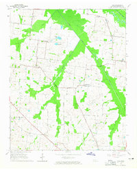
 1951 Sunnyhill1951 Print · USGSWest Tennessee’s rural landscape unfolds around Brownsville in the early fifties, where the town’s eastern expansion meets the wetlands of the Hatchie. Family historians can trace local roots through sites like Springfield Sch, Marvin Chapel, and the Knights of Pythias Cem.
 - 1952 Map of Stanton
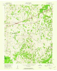
 1952 Stanton1952 Print · USGSWestern Tennessee at the start of the fifties was a landscape of rail-connected towns and crossroads communities. Genealogists can trace family roots through numerous rural landmarks like Wesley Cem, Fredonia Sch, and the community of Keeling.3 unique versions available
 - 1952 Map of Dancyville
 1952 Dancyville1952 Print · USGSDancyville and the surrounding West Tennessee countryside appear in the early fifties as a landscape of small crossroads and creek-bottom farms. Genealogists can trace family landmarks like McKenzie Chapel, Wilkinson Corner, and the St Johns Sch Cem.2 unique versions available
 - 1952 Map of Gates, 1953 Print
 1952 Gates1953 Print · USGSLauderdale and Haywood Counties are shown in the early fifties as the rural landscape centered on the ILLINOIS CENTRAL rail line. Genealogists can trace family footprints through numerous small landmarks like Nelson Chapel, Woodville Sch, and Crossroads Cem.3 unique versions available
 - 1952 Map of Chestnut Bluff, 1953 Print
 1952 Chestnut Bluff1953 Print · USGSCrockett County and its river-carved borders are captured here in the early fifties, before modern highway expansion altered the rural landscape. Researchers can locate family landmarks and community anchors like Hellens Bluff Sch, Archer Chapel, and the Young Cem.2 unique versions available
 - 1952 Map of Stanton, 1958 Print
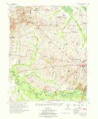
 1952 Stanton1958 Print · USGSMid-century West Tennessee comes to life here as the rail-driven town of Stanton and the crossroads at Dancyville anchor a landscape of bottomlands and family farms. Trace the roots of local communities through landmarks like Yum Yum, Gailor High Sch, and the Antioch Ch.
 - 1956 Map of Blytheville, 1964 Print
 1956 Blytheville1964 Print · USGSWest Tennessee and the Arkansas Delta come alive in this mid-century survey of the river-and-rail corridor connecting Memphis to Jackson. Genealogists and historians can trace the rail lines of the Louisville and Nashville RR and locate landmarks like Western State Hospital or Fort Pillow State Prison Farm.2 unique versions available
 - 1959 Map of Blytheville
 1959 Blytheville1959 Print · USGSWest Tennessee and Northeast Arkansas meet along the river in the late fifties, during a period of steady industrial and agricultural growth. Genealogists can trace the rail corridors of the Illinois Central through Jackson or explore landmarks like Shiloh National Military Park and Fort Pillow State Prison.
 - 1959 Map of Bells, 1960 Print
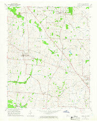
 1959 Bells1960 Print · USGSWest Tennessee agriculture and rail transport intersect in the late fifties where the Gulf Mobile and Ohio meets the L&N at Bells. Local researchers can trace family roots through several rural landmarks, including Morris Hill Sch, Belleview Cem, and East Haywood Ch.2 unique versions available
 - 1959 Map of Denmark, 1960 Print
 1959 Denmark1960 Print · USGSWest Tennessee rural life is documented here in the late fifties, spanning the Haywood and Madison county line. Researchers can locate family landmarks like Bond Cem, local schools such as Lower Ingram Sch, and the village of Denmark.3 unique versions available
 - 1959 Map of Hillville, 1964 Print
 1959 Hillville1964 Print · USGSThe tri-county border of Haywood, Hardeman, and Fayette counties comes alive in this late 1950s survey of the Hatchie River basin. Researchers can trace rural life through numerous family cemeteries and country churches like Cedar Chapel, Mt Tabor Ch, and the crossroads at Hillville.
 - 1961 Map of Jones, 1963 Print
 1961 Jones1963 Print · USGSHaywood and Crockett counties are captured here in the early sixties, a landscape defined by the winding South Fork Forked Deer River. Family researchers can trace ancestral locations near Owl City, Wortham Chapel Cemetery, and the Louisville and Nashville rail line.2 unique versions available
 - 1961 Map of Rialto, 1963 Print
 1961 Rialto1963 Print · USGSWest Tennessee in the early sixties was a landscape of river-bottom farms and interconnected parish life along the Hatchie River. Researchers can trace the heritage of Covington and Ripley, alongside rural landmarks like the Fort Pillow State Prison Farm and Plumer Grove Ch & Sch.
 - 1961 Map of Mercer, 1964 Print
 1961 Mercer1964 Print · USGSThe Hatchie River floodplain in the early sixties is a landscape of oxbow lakes and rail-side settlements. Researchers can trace family history at Hayes Chapel Cem, find the site of the Brown Sch, or locate the Old Ferry Landing.2 unique versions available
 - 1961 Map of Halls, 1965 Print
 1961 Halls1965 Print · USGSLauderdale and Dyer counties are shown in the early sixties as the West Tennessee landscape hummed with activity along the Illinois Central tracks. Researchers can trace rural lineages through dozens of named sites like Miller Chapel Cem, Benton Sch, and the U. S. Military Reservation.
 - 1962 Map of Rialto
 1962 Rialto1962 Print · USGSTipton and Lauderdale counties are mapped here in the early sixties, showing a landscape defined by the Hatchie River and the Illinois Central line. Genealogists can locate many local landmarks, including Rialto Ch & Sch, Canaan Cem, and the Fort Pillow State Prison Farm.
 - 1964 Map of Tibbs, 1965 Print
 1964 Tibbs1965 Print · USGSHaywood County in the mid-sixties reveals a rural landscape of scattered hamlets and family-named schools before modern consolidation. Genealogists can trace the locations of Antioch Ch, Woodlawn Cem, and early educational sites like Hickory Grove Sch.2 unique versions available
 - 1964 Map of Turnpike, 1965 Print
 1964 Turnpike1965 Print · USGSThe Hatchie River lowlands of West Tennessee are captured here in the mid-sixties, showing a landscape defined by river bends and wetland basins. Researchers can locate vanished landmarks like New Hope School, Turnpike, and family sites such as Estes Cemetery and Walker School.2 unique versions available
 - 1964 Map of Durhamville, 1965 Print
 1964 Durhamville1965 Print · USGSThe West Tennessee borderlands of Haywood and Lauderdale counties are documented here in the mid-1960s. Genealogists and local historians can trace family locations near Durhamville, Nutbush, and landmarks such as St Pauls Ch or Holmes Cem.2 unique versions available
 - 1964 Map of Maury City, 1966 Print
 1964 Maury City1966 Print · USGSCrockett County life in the mid-1960s is centered on rural crossroads and the rail line connecting Maury City to Alamo. Researchers can trace family history through a network of local landmarks like Hamlett Robertson Sch and the Pond Creek Cem.2 unique versions available
 - 1970 Map of Brownsville
 1970 Brownsville1970 Print · USGSHaywood County in the late sixties and early seventies is defined by its deep river bottomlands and scattered rural crossroads. Genealogists and researchers can trace family landmarks and vanished schools like Nutbush, Durhamville, and the Flag Grove Sch.
Showing maps 1-25 of 111
Top cities of Haywood County
Frequently asked questions
- What are the different types of historical maps available for Haywood County?
- What is the oldest map of Haywood County?
- Where can I purchase historical maps of Haywood County for my home or office?
- Where can I download high-res historical maps of Haywood County?
- Are there historical topographic maps available for Haywood County?
- Is there historical aerial imagery available for Haywood County?
- Where are historical maps of Haywood County sourced from?