1939 Map of Halls
USGS Topo · Published 1943About this map
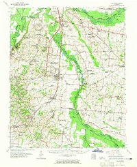
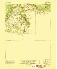
Halls serves as the primary rail hub in this survey, where the Illinois Central railroad cuts north through the agricultural landscape of West Tennessee. The terrain is defined by the winding paths of the South Fork Forked Deer River and North Fork Forked Deer River, which divide Dyer County and Lauderdale County. This era shows a densely settled rural society organized around small crossroads and shared community spaces, as seen in the frequent combination of faith and education at sites like Mt Zion Ch Sch & Cem and Bene Ch & Sch. Genealogists will find a wealth of family landmarks and rural burial grounds, including the Butterworth Cem & Ch and King Cem & Ch, scattered among the river bottoms and along the sharp elevation of the Entire escarpment.
Find a feature on this map
43 named features on this map. Tap any name to fly to it.
Don’t see what you’re looking for? This feature index may not catch every label — zoom into the map to look around manually.
Map Details
Editions of this 1939 Halls Map
This is the sole edition of this map. No revisions or reprints were ever made.