
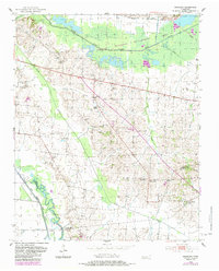
1952 Map of Bonicord
USGS Topo · Published 1953About this map
The North Fork Forked Deer River and South Fork Forked Deer River define the northern and southern reaches of this West Tennessee landscape in the early 1950s. The terrain is characterized by a dense network of small family and community hubs, often centered around churches and burial grounds. Small settlements like Bonicord, Hawkinsville, and Cross Roads serve as local anchors, while the countryside is dotted with sites like Sorrell Chapel and Miller Chapel.
Find a feature on this map
34 named features on this map. Tap any name to fly to it.
Don’t see what you’re looking for? This feature index may not catch every label — zoom into the map to look around manually.
Map Details
Editions of this 1952 Bonicord Map
2 editions found
Other maps of this area

1939 · Dyersburg
USGS Topo · 1:62,500

1939 · Halls
USGS Topo · 1:62,500

1952 · Gates
USGS Topo · 1:24,000

1952 · Newbern
USGS Topo · 1:24,000

1952 · Dyersburg
USGS Topo · 1:24,000

1952 · Chestnut Bluff
USGS Topo · 1:24,000

1952 · Fowlkes
USGS Topo · 1:24,000

1956 · Dyersburg
USGS Topo · 1:250,000

1956 · Blytheville
USGS Topo · 1:250,000

1959 · Blytheville
USGS Topo · 1:250,000