
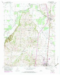
1952 Map of Fowlkes
USGS Topo · Published 1954About this map
The South Fork Forked Deer River and its meandering tributaries dominate this mid-century West Tennessee landscape, winding through a complex network of levees and low-lying wetlands. The high ground between the river forks is dotted with rural centers like Double Bridges and Fowlkes, where the Illinois Central railroad corridor serves as the primary industrial axis for the region. A notable feature of the era is the expansive U S Military Reservation (Inactive Air Base) situated just north of Halls, signifying the lingering footprint of wartime military infrastructure in rural Dyer and Lauderdale counties. Genealogists will find a high density of family-named landmarks and institutions, including Williams Chapel, Benton Sch, and the Butterworth Cem. The map provides a detailed view of these rural communities as they transitioned from river-dependent settlements to more road-connected agricultural hubs.
Find a feature on this map
39 named features on this map. Tap any name to fly to it.
Don’t see what you’re looking for? This feature index may not catch every label — zoom into the map to look around manually.
Map Details
Editions of this 1952 Fowlkes Map
2 editions found
Other maps of this area

1939 · Dyersburg
USGS Topo · 1:62,500

1939 · Hales Point
USGS Topo · 1:62,500

1939 · Caruthersville
USGS Topo · 1:62,500

1939 · Halls
USGS Topo · 1:62,500

1951 · Caruthersville
USGS Topo · 1:62,500

1952 · Hales Point
USGS Topo · 1:62,500

1952 · Gates
USGS Topo · 1:24,000

1952 · Bonicord
USGS Topo · 1:24,000

1952 · Newbern
USGS Topo · 1:24,000

1952 · Dyersburg
USGS Topo · 1:24,000