
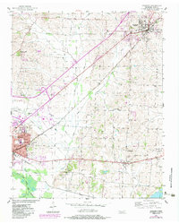
1952 Map of Newbern
USGS Topo · Published 1953About this map
Newbern serves as the primary hub in this West Tennessee landscape, anchored by the Illinois Central railroad corridor that cuts diagonally across the terrain. To the southwest, a portion of Dyersburg is visible, including community institutions like the Jennie Bell Sch and Neal Thomas Sch. The area is characterized by a high density of small family cemeteries and rural congregations, such as Hurricane Hill Ch and the Gauldin Cem, which dot the uplands between the winding paths of Light Creek and Jones Creek.
Find a feature on this map
35 named features on this map. Tap any name to fly to it.
Don’t see what you’re looking for? This feature index may not catch every label — zoom into the map to look around manually.
Map Details
Editions of this 1952 Newbern Map
2 editions found
Other maps of this area

1939 · Dyersburg
USGS Topo · 1:62,500

1939 · Halls
USGS Topo · 1:62,500

1952 · Bonicord
USGS Topo · 1:24,000

1952 · Lane
USGS Topo · 1:24,000

1952 · Dyersburg
USGS Topo · 1:24,000

1952 · Miston
USGS Topo · 1:24,000

1952 · Fowlkes
USGS Topo · 1:24,000

1956 · Dyersburg
USGS Topo · 1:250,000

1956 · Blytheville
USGS Topo · 1:250,000

1959 · Blytheville
USGS Topo · 1:250,000