
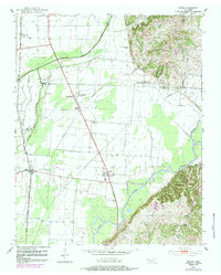
1952 Map of Miston
USGS Topo · Published 1953About this map
The Obion River winds through the bottomlands of western Tennessee in this 1952 survey, defining a landscape shaped by water and agriculture. The western edge of the map follows the corridor of the Illinois Central railroad, which connects the small settlements of Horn Ridge and Miston. This period captures a highly localized rural society, evidenced by the density of community landmarks such as Cunningham Sch and numerous country churches including Woodward Chapel, Rehoboth Ch, and Solid Rock Ch.
Find a feature on this map
29 named features on this map. Tap any name to fly to it.
Don’t see what you’re looking for? This feature index may not catch every label — zoom into the map to look around manually.
Map Details
Editions of this 1952 Miston Map
2 editions found
Other maps of this area

1925 · Reelfoot Lake
USGS Topo · 1:62,500

1939 · Reelfoot Lake
USGS Topo · 1:62,500

1939 · Portageville
USGS Topo · 1:62,500

1939 · Dyersburg
USGS Topo · 1:62,500

1939 · Caruthersville
USGS Topo · 1:62,500

1951 · Caruthersville
USGS Topo · 1:62,500

1952 · Newbern
USGS Topo · 1:24,000

1952 · Lane
USGS Topo · 1:24,000

1952 · Dyersburg
USGS Topo · 1:24,000

1955 · Portageville
USGS Topo · 1:62,500