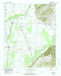
1952 Map of Miston
USGS Topo · Published 1984About this map
The Obion River and its complex network of drainage ditches and bayous define this landscape on the border of Lake, Dyer, and Obion Counties. The Illinois Central Gulf railroad line cuts through the western flats, supporting the small settlements of Miston and Bogota. In the eastern half of the map, the terrain rises toward Brown Ridge, where the irregular contours of the hills contrast sharply with the channelized agricultural land to the west. This 1952 survey, photorevised in 1983, captures a rural community organized around its spiritual and educational centers, such as Rehoboth Ch, Bruces Chapel, and Cunningham Sch. Small family-named landmarks like Horn Ridge Cem and Bledsoe Cem provide essential anchor points for genealogists researching the residents who lived between Running Reelfoot Bayou and the river's meandering path near Millsfield.
Find a feature on this map
27 named features on this map. Tap any name to fly to it.
Don’t see what you’re looking for? This feature index may not catch every label — zoom into the map to look around manually.
Map Details
Editions of this 1952 Miston Map
2 editions found
Other maps of this area

1925 · Reelfoot Lake
USGS Topo · 1:62,500

1939 · Reelfoot Lake
USGS Topo · 1:62,500

1939 · Portageville
USGS Topo · 1:62,500

1939 · Dyersburg
USGS Topo · 1:62,500

1939 · Caruthersville
USGS Topo · 1:62,500

1951 · Caruthersville
USGS Topo · 1:62,500

1952 · Newbern
USGS Topo · 1:24,000

1952 · Lane
USGS Topo · 1:24,000

1952 · Dyersburg
USGS Topo · 1:24,000

1952 · Miston
USGS Topo · 1:24,000