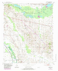
1952 Map of Bonicord
USGS Topo · Published 1983About this map
Tigrett Wildlife Management Area dominates the northern reaches of this Dyer County landscape, where the North Fork Forked Deer River meanders through wet bottomlands. The settlement of Bonicord sits at a crossroads in the central uplands, surrounded by a high density of rural institutions that suggest a deeply rooted mid-century community. Small family and church-affiliated burial grounds, such as Clay Cem and Williams Chapel Cem, are scattered across the terrain, providing essential data points for genealogists.
Find a feature on this map
38 named features on this map. Tap any name to fly to it.
Don’t see what you’re looking for? This feature index may not catch every label — zoom into the map to look around manually.
Map Details
Editions of this 1952 Bonicord Map
2 editions found
Other maps of this area

1939 · Dyersburg
USGS Topo · 1:62,500

1939 · Halls
USGS Topo · 1:62,500

1952 · Gates
USGS Topo · 1:24,000

1952 · Bonicord
USGS Topo · 1:24,000

1952 · Newbern
USGS Topo · 1:24,000

1952 · Dyersburg
USGS Topo · 1:24,000

1952 · Chestnut Bluff
USGS Topo · 1:24,000

1952 · Fowlkes
USGS Topo · 1:24,000

1956 · Dyersburg
USGS Topo · 1:250,000

1956 · Blytheville
USGS Topo · 1:250,000