1950s Maps of Humphreys County, Tennessee
Explore 20 historic maps of Humphreys County from the 1950s. These maps offer a rare glimpse into what life looked like during the 1950s — showing old roads, neighborhoods, homes, and landmarks that have changed or disappeared over time.
Whether you're researching your family's past, planning a metal detecting trip, or studying how Humphreys County's landscape evolved across the 1950s, these high-resolution maps are a powerful tool for exploring the history of this region.
- Focus on a specific era: All maps on this page are from the 1950s, giving you a focused view of this time period.
- See what’s changed: Compare century-old streets, trails, and buildings to today's modern landscape using overlays and satellite layers.
- Research with precision: Use these maps for genealogy, historical research, land use analysis, or educational projects.
- View, download, or print: Maps are fully viewable online in high resolution, and can be downloaded or printed for your own records.
Start exploring Humphreys County's history through authentic maps from the 1950s. This is your window into the past.
Humphreys County, TN maps
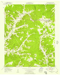
(20)- 1950 Map of Johnsonville, 1952 Print
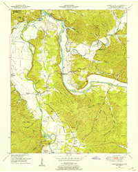
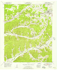
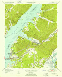 1950 Johnsonville1952 Print · USGSMid-century Tennessee geography is defined here by the creation of Kentucky Lake and the resulting relocation of river communities. Genealogists and historians can trace the transition from Old Johnsonville to New Johnsonville, alongside landmarks like Fairview Sch and Denver.4 unique versions available
 - 1950 Map of Rockport, 1953 Print
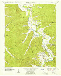
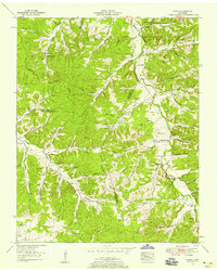
 1950 Rockport1953 Print · USGSBenton and Humphreys counties are shown during the early years of the Kentucky Lake reservoir, where new shorelines met established rural communities. Researchers can locate family burial grounds like Hardin Cem or trace landmarks like Rockport Landing and Camp Mack Morris.4 unique versions available
 - 1950 Map of Halls Creek, 1953 Print
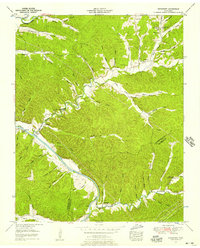
 1950 Halls Creek1953 Print · USGSHumphreys and Houston Counties appear here in the early fifties, showing a rural landscape shaped by the new waters of Kentucky Lake. Genealogists can trace family landmarks and schools like Elizabeth Sch or find ancestral sites at Beecham Cem and Shiloh Cem.3 unique versions available
 - 1950 Map of Camden, 1953 Print
 1950 Camden1953 Print · USGSMid-century Benton County shows the impact of the Tennessee Valley Authority's reservoir projects alongside the established hub of Camden. Genealogists can trace family names and rural life through landmarks like Toll Chapel School, Morris Chapel, and the Blanchard Cem.6 unique versions available
 - 1950 Map of Hurricane Mills, 1953 Print
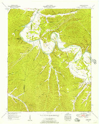
 1950 Hurricane Mills1953 Print · USGSThe Tennessee river country in the early fifties shows a landscape of river-bottom farming and ridge-top settlements. Researchers can trace family history through numerous rural landmarks like Hurricane Mills School, Bone Cem, and the river crossing at Tanksley Bridge.2 unique versions available
 - 1950 Map of Waverly, 1953 Print
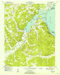
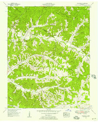
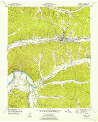 1950 Waverly1953 Print · USGSMid-century Humphreys County is centered on the railroad hub of Waverly and the nearby confluence of the Duck River and Kentucky Lake. Researchers can locate dozens of family-named landmarks and burial grounds, such as Pigeon Roost, Thompson Cemetery, and Spann School.4 unique versions available
 - 1950 Map of Lobelville, 1953 Print
 1950 Lobelville1953 Print · USGSPerry County and the Buffalo River valley are captured in the early 1950s, showing a landscape of ridge-and-hollow farmsteads and riverside bottoms. Genealogists can locate family burial grounds like the Dodson Cemeteries or trace the area around Lobelville and Standing Rock.3 unique versions available
 - 1952 Map of Bucksnort, 1957 Print
 1952 Bucksnort1957 Print · USGSThe Duck River valley in the early 1950s reveals a landscape of isolated hollows and deep-rooted family homesteads along the Humphreys-Hickman line. Researchers can trace rural life through landmarks like Old Furnace Sch, the Water Valley Church, and cemeteries like Sanders Cem.2 unique versions available
 - 1952 Map of Mc Ewen, 1957 Print
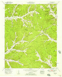
 1952 Mc Ewen1957 Print · USGSMcEwen and the surrounding Humphreys County hollows are captured here in the early 1950s as a landscape of small farms and family cemeteries. Trace the path of the Nashville Chattanooga and St Louis Railway and find landmarks like Liberty Sch or McCandless Bridge.3 unique versions available
 - 1952 Map of Woolworth, 1957 Print
 1952 Woolworth1957 Print · USGSThe rural Tennessee backcountry along the Houston and Humphreys County line is captured here in the early fifties. Genealogists and researchers can trace family roots through numerous landmarks like Batson Cem, Mt Olivet Hill Sch, and Woolworth.3 unique versions available
 - 1952 Map of Spot, 1957 Print
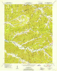
 1952 Spot1957 Print · USGSHickman County is a labyrinth of ridges and named hollows at the start of the fifties, revealing the deep-rooted family legacy of this rural region. Genealogists can trace early homesteads near Spot and local landmarks like Pleasant Valley Ch, Pinewood Lookout Tower, and McMackins Cem.3 unique versions available
 - 1952 Map of Coble, 1957 Print
 1952 Coble1957 Print · USGSHickman County life in the early fifties revolves around the great meanders of the Duck River. Researchers can locate several family cemeteries and historical river crossings, including Grandmother Ford, Murphree Cem, and the settlement of Only.2 unique versions available
 - 1953 Map of Tennessee City, 1957 Print
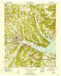
 1953 Tennessee City1957 Print · USGSThe border of Humphreys and Dickson counties comes alive in the 1950s, showing a landscape defined by the Nashville Chattanooga and St Louis rail line. Researchers can locate numerous family burial sites like Washburn Cemetery and Few Chapel Cemetery, along with the old Broadway of America highway.3 unique versions available
 - 1953 Map of Ruskin, 1958 Print
 1953 Ruskin1958 Print · USGSThe rural borders of Dickson, Houston, and Humphreys counties are captured here in the early fifties, showing a landscape defined by deep hollows and high ridges. Family researchers can locate dozens of remote burial sites like Dotson Cem and Yates Cem, alongside crossroads communities like Ruskin and Thompsons Crossroads.3 unique versions available
 - 1956 Map of Dyersburg, 1960 Print
 1956 Dyersburg1960 Print · USGSThe Four Rivers region comes alive in the mid-fifties, capturing the intricate borderlands of Tennessee, Kentucky, and Missouri. Genealogists and historians can trace the rail-and-river networks connecting Dyersburg, Caruthersville, and the shoreline of Reelfoot Lake.4 unique versions available
 - 1956 Map of Columbia, 1960 Print
 1956 Columbia1960 Print · USGSMiddle Tennessee in the mid-fifties presents a landscape of established river towns and critical rail hubs before the arrival of the modern interstate system. Researchers can trace the routes of the Louisville and Nashville railroad or locate historic landmarks like Stones River National Military Park and the Tennessee National Wildlife Refuge.6 unique versions available
 - 1956 Map of Blytheville, 1964 Print
 1956 Blytheville1964 Print · USGSWest Tennessee and the Arkansas Delta come alive in this mid-century survey of the river-and-rail corridor connecting Memphis to Jackson. Genealogists and historians can trace the rail lines of the Louisville and Nashville RR and locate landmarks like Western State Hospital or Fort Pillow State Prison Farm.2 unique versions available
 - 1956 Map of Nashville, 1971 Print
 1956 Nashville1971 Print · USGSThe Tennessee-Kentucky borderlands come into focus in the mid-1960s as major reservoir projects transformed the Cumberland and Tennessee river valleys. Researchers can trace the rail networks of the Louisville and Nashville and visit sites like Fort Campbell and Fort Donelson National Military Park.2 unique versions available
 - 1959 Map of Nashville
 1959 Nashville1959 Print · USGSMiddle Tennessee and Southern Kentucky come into focus during the late fifties, showing the region's transition into a modern transportation and military hub. Researchers can trace the sprawling Fort Campbell Military Reservation or locate historic rail stops along the Tennessee Central Ry and Illinois Central RR.
 - 1959 Map of Blytheville
 1959 Blytheville1959 Print · USGSWest Tennessee and Northeast Arkansas meet along the river in the late fifties, during a period of steady industrial and agricultural growth. Genealogists can trace the rail corridors of the Illinois Central through Jackson or explore landmarks like Shiloh National Military Park and Fort Pillow State Prison.
End of results
Showing maps 1-20 of 20
Top cities of Humphreys County
Frequently asked questions
- What are the different types of historical maps available for Humphreys County?
- What is the oldest map of Humphreys County?
- Where can I purchase historical maps of Humphreys County for my home or office?
- Where can I download high-res historical maps of Humphreys County?
- Are there historical topographic maps available for Humphreys County?
- Is there historical aerial imagery available for Humphreys County?
- Where are historical maps of Humphreys County sourced from?