1990s Maps of Johnson County, Tennessee
Explore 2 historic maps of Johnson County from the 1990s. These maps offer a rare glimpse into what life looked like during the 1990s — showing old roads, neighborhoods, homes, and landmarks that have changed or disappeared over time.
Whether you're researching your family's past, planning a metal detecting trip, or studying how Johnson County's landscape evolved across the 1990s, these high-resolution maps are a powerful tool for exploring the history of this region.
- Focus on a specific era: All maps on this page are from the 1990s, giving you a focused view of this time period.
- See what’s changed: Compare century-old streets, trails, and buildings to today's modern landscape using overlays and satellite layers.
- Research with precision: Use these maps for genealogy, historical research, land use analysis, or educational projects.
- View, download, or print: Maps are fully viewable online in high resolution, and can be downloaded or printed for your own records.
Start exploring Johnson County's history through authentic maps from the 1990s. This is your window into the past.
Johnson County, TN maps
(2)- 1994 Map of Elk Mills, 1998 Print
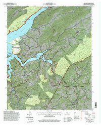 1994 Elk Mills1998 Print · USGSThe Tennessee-North Carolina border country in the 1990s reveals a landscape of isolated mountain settlements and Forest Service wilderness. Trace local genealogy and industry through family landmarks like Grindstaff Cemetery, Stout Hill Church, and the Strip Mine near Dry Run.
 - 1994 Map of Sherwood, 1998 Print
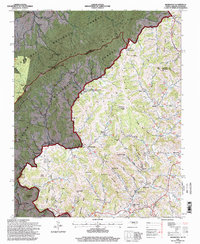 1994 Sherwood1998 Print · USGSWatauga County high country life is centered on crossroads like Sherwood and Sugar Grove during the 1990s. Genealogists can trace family names through landmarks like Henson Hollow and locate historic sites such as Beaverdam Sch and Zion Hill Ch.
End of results
Showing maps 1-2 of 2
Top cities of Johnson County
Frequently asked questions
- What are the different types of historical maps available for Johnson County?
- What is the oldest map of Johnson County?
- Where can I purchase historical maps of Johnson County for my home or office?
- Where can I download high-res historical maps of Johnson County?
- Are there historical topographic maps available for Johnson County?
- Is there historical aerial imagery available for Johnson County?
- Where are historical maps of Johnson County sourced from?