1970s Maps of Hales Point, Tennessee
Explore 2 historic maps of Hales Point from the 1970s. These maps offer a rare glimpse into what life looked like during the 1970s — showing old roads, neighborhoods, homes, and landmarks that have changed or disappeared over time.
Whether you're researching your family's past, planning a metal detecting trip, or studying how Hales Point's landscape evolved across the 1970s, these high-resolution maps are a powerful tool for exploring the history of this region.
- Focus on a specific era: All maps on this page are from the 1970s, giving you a focused view of this time period.
- See what’s changed: Compare century-old streets, trails, and buildings to today's modern landscape using overlays and satellite layers.
- Research with precision: Use these maps for genealogy, historical research, land use analysis, or educational projects.
- View, download, or print: Maps are fully viewable online in high resolution, and can be downloaded or printed for your own records.
Start exploring Hales Point's history through authentic maps from the 1970s. This is your window into the past.
Hales Point, TN maps
(2)- 1972 Map of Chic, 1975 Print
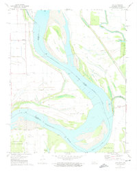 1972 Chic1975 Print · USGSThe Mississippi River meanders through the Tennessee and Arkansas borderlands in the early seventies, a landscape shaped by river engineering and rural life. Researchers can trace family history at Marys Chapel or locate old river access points like Hickman Landing and Hales Point.2 unique versions available
 - 1977 Map of Hales Point
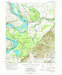 1977 Hales Point1977 Print · USGSLauderdale County, Tennessee, is mapped here in the mid-seventies, showing a landscape shaped by the Mississippi River and its historic shifts. Researchers can trace the heritage of local communities like Hales Point, locate family plots at Buckner Cem, and find old rural landmarks including Arp Sch and Marys Chapel.
End of results
Showing maps 1-2 of 2
Top cities near Hales Point
- Dyersburg historical maps
- Blytheville historical maps
- Ripley historical maps
- Halls historical maps
- Steele historical maps
- Henning historical maps
See more
Frequently asked questions
- What are the different types of historical maps available for Hales Point?
- What is the oldest map of Hales Point?
- Where can I purchase historical maps of Hales Point for my home or office?
- Where can I download high-res historical maps of Hales Point?
- Are there historical topographic maps available for Hales Point?
- Is there historical aerial imagery available for Hales Point?
- Where are historical maps of Hales Point sourced from?