1950s Maps of Macon County, Tennessee
Explore 11 historic maps of Macon County from the 1950s. These maps offer a rare glimpse into what life looked like during the 1950s — showing old roads, neighborhoods, homes, and landmarks that have changed or disappeared over time.
Whether you're researching your family's past, planning a metal detecting trip, or studying how Macon County's landscape evolved across the 1950s, these high-resolution maps are a powerful tool for exploring the history of this region.
- Focus on a specific era: All maps on this page are from the 1950s, giving you a focused view of this time period.
- See what’s changed: Compare century-old streets, trails, and buildings to today's modern landscape using overlays and satellite layers.
- Research with precision: Use these maps for genealogy, historical research, land use analysis, or educational projects.
- View, download, or print: Maps are fully viewable online in high resolution, and can be downloaded or printed for your own records.
Start exploring Macon County's history through authentic maps from the 1950s. This is your window into the past.
Macon County, TN maps
(11)- 1954 Map of Fountain Run, 1955 Print
 1954 Fountain Run1955 Print · USGSSouthern Kentucky and northern Tennessee meet along the Barren River in the mid-fifties, showing a rural landscape of ridges and hollows. Genealogists can trace family roots through numerous local landmarks like Fountain Run Sch, Old Rocky Hill Ch, and Akersville.2 unique versions available
 - 1954 Map of Petroleum, 1955 Print
 1954 Petroleum1955 Print · USGSAllen County, Kentucky, supported a thriving rural oil economy in the mid-1950s centered around the namesake town of Petroleum. Researchers can locate numerous active Oil Wells and trace family heritage through sites like White Plains Sch and Mt Pleasant Ch.4 unique versions available
 - 1954 Map of Holland, 1955 Print
 1954 Holland1955 Print · USGSThe Allen Co Macon Co line and the winding Barren River define this rural landscape during the mid-fifties. Genealogists and local historians can trace family locations through numerous named sites like Mt Zion Sch, Liberty Ch, and the community of Holland.
 - 1956 Map of Corbin, 1966 Print
 1956 Corbin1966 Print · USGSThe Kentucky and Tennessee borderlands are captured here in the mid-fifties, showing the region's shift toward modern interstate travel and reservoir development. Genealogists and historians can trace old community lines near Albany and Monticello or locate early rail junctions along the Southern and Tennessee Central lines.3 unique versions available
 - 1956 Map of Nashville, 1971 Print
 1956 Nashville1971 Print · USGSThe Tennessee-Kentucky borderlands come into focus in the mid-1960s as major reservoir projects transformed the Cumberland and Tennessee river valleys. Researchers can trace the rail networks of the Louisville and Nashville and visit sites like Fort Campbell and Fort Donelson National Military Park.2 unique versions available
 - 1958 Map of Corbin
 1958 Corbin1958 Print · USGSThe Upper Cumberland borderlands appear in the late 1950s as massive reservoirs and early atomic-era growth reshape the region. Trace family roots and vanished landmarks near Lake Cumberland, Oak Ridge, and the Cumberland National Forest.
 - 1958 Map of Westmoreland, 1959 Print
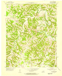
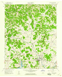
 1958 Westmoreland1959 Print · USGSUpper Middle Tennessee in the late fifties was a landscape of ridge-top farms and valley rail hubs. You can trace the Louisville and Nashville line through Westmoreland or locate old community sites like Leaths Chapel Sch and Rocky Mound.2 unique versions available
 - 1958 Map of Lafayette, 1959 Print
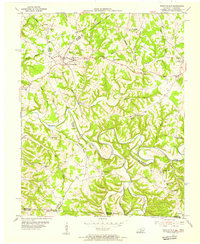
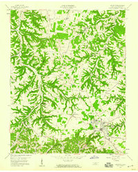 1958 Lafayette1959 Print · USGSMacon County in the late fifties was a landscape of deep hollows and family homesteads centered on the growing hub of Lafayette. Genealogists and researchers can locate old landmarks like New Bethel Ch, the Orphanage, and the Drive-in Theater.3 unique versions available
 - 1958 Map of Hartsville, 1960 Print
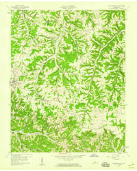
 1958 Hartsville1960 Print · USGSMid-century Trousdale County comes to life as the Cumberland River valley adjusts to the new waters of Old Hickory Lake. Researchers can trace old family roots at Wolf Hill Cem, follow the Louisville and Nashville Railroad, or locate rural landmarks like Leaths Chapel.3 unique versions available
 - 1959 Map of Nashville
 1959 Nashville1959 Print · USGSMiddle Tennessee and Southern Kentucky come into focus during the late fifties, showing the region's transition into a modern transportation and military hub. Researchers can trace the sprawling Fort Campbell Military Reservation or locate historic rail stops along the Tennessee Central Ry and Illinois Central RR.
 - 1959 Map of Hillsdale, 1960 Print
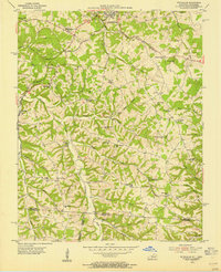
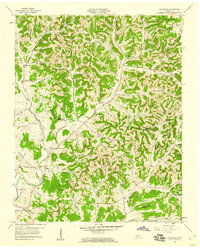 1959 Hillsdale1960 Print · USGSMacon and Trousdale counties come into focus during the late fifties, showcasing a rural Tennessee landscape defined by narrow hollows and ridge-top roads. Genealogists can trace family names through dozens of landmarks like Wilburn Cem, Stafford Cem, and the community of New Harmony.2 unique versions available
End of results
Showing maps 1-11 of 11
Top cities of Macon County
Frequently asked questions
- What are the different types of historical maps available for Macon County?
- What is the oldest map of Macon County?
- Where can I purchase historical maps of Macon County for my home or office?
- Where can I download high-res historical maps of Macon County?
- Are there historical topographic maps available for Macon County?
- Is there historical aerial imagery available for Macon County?
- Where are historical maps of Macon County sourced from?