
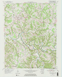
1954 Map of Fountain Run
USGS Topo · Published 1955About this map
The Barren River meanders across the center of this Kentucky-Tennessee border region, carving through a landscape defined by sharp ridges and deep creek hollows. The settlement of Fountain Run serves as a local hub in Monroe County, surrounded by a dense network of country churches and schools that reflect the rural community life of the mid-1950s. To the south and east, the map captures the small communities of Akersville and Flippin, along with the curiously named Bugtussle near the Tennessee line. Notable for genealogists, the survey identifies several family-named landmarks and historical institutions such as the Old Walnut Grove Sch and Old Rocky Hill Ch. The presence of a prominent Pipe Line running through the northern hills highlights the post-war industrial infrastructure integrated into this traditionally agricultural topography.
Find a feature on this map
55 named features on this map. Tap any name to fly to it.
Don’t see what you’re looking for? This feature index may not catch every label — zoom into the map to look around manually.
Map Details
Editions of this 1954 Fountain Run Map
2 editions found
Other maps of this area

1926 · Scottsville
USGS Topo · 1:62,500

1931 · Lafayette
USGS Topo · 1:62,500

1931 · Red Boiling Springs
USGS Topo · 1:62,500

1953 · Tracy
USGS Topo · 1:24,000

1953 · Freedom
USGS Topo · 1:24,000

1954 · Austin
USGS Topo · 1:24,000

1954 · Gamaliel
USGS Topo · 1:24,000

1954 · Holland
USGS Topo · 1:24,000

1956 · Corbin
USGS Topo · 1:250,000

1956 · Nashville
USGS Topo · 1:250,000