1990s Maps of Macon County, Tennessee
Explore 2 historic maps of Macon County from the 1990s. These maps offer a rare glimpse into what life looked like during the 1990s — showing old roads, neighborhoods, homes, and landmarks that have changed or disappeared over time.
Whether you're researching your family's past, planning a metal detecting trip, or studying how Macon County's landscape evolved across the 1990s, these high-resolution maps are a powerful tool for exploring the history of this region.
- Focus on a specific era: All maps on this page are from the 1990s, giving you a focused view of this time period.
- See what’s changed: Compare century-old streets, trails, and buildings to today's modern landscape using overlays and satellite layers.
- Research with precision: Use these maps for genealogy, historical research, land use analysis, or educational projects.
- View, download, or print: Maps are fully viewable online in high resolution, and can be downloaded or printed for your own records.
Start exploring Macon County's history through authentic maps from the 1990s. This is your window into the past.
Macon County, TN maps
(2)- 1994 Map of Hillsdale, 1997 Print
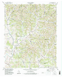 1994 Hillsdale1997 Print · USGSThe rural borders of Macon and Trousdale counties come into focus in the mid-1990s, revealing a landscape of family-named hollows and ridge-top settlements. Genealogists and local researchers can trace historic community hubs like Hillsdale, Horsleys, and Beech Hill alongside numerous unnamed cemeteries and local landmarks.
 - 1994 Map of Hartsville, 1997 Print
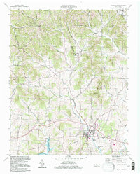 1994 Hartsville1997 Print · USGSHartsville and the surrounding Trousdale County countryside are shown here in the mid-nineties, just north of the Cumberland River. Researchers can trace rural lineages through landmarks like Leaths Chapel, Willow Grove Cem, and the old Ward High Sch.
End of results
Showing maps 1-2 of 2
Top cities of Macon County
Frequently asked questions
- What are the different types of historical maps available for Macon County?
- What is the oldest map of Macon County?
- Where can I purchase historical maps of Macon County for my home or office?
- Where can I download high-res historical maps of Macon County?
- Are there historical topographic maps available for Macon County?
- Is there historical aerial imagery available for Macon County?
- Where are historical maps of Macon County sourced from?