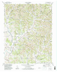
1994 Map of Hillsdale
USGS Topo · Published 1997About this map
The Middle Fork Goose Creek and its many winding hollows carve a complex landscape across the borders of Macon, Trousdale, and Smith counties. This rural interior is characterized by small, dispersed settlements like Hillsdale, New Harmony, and Beech Grove, connected by a network of narrow roads following the creek beds and ridges. Community life centers on landmarks such as Hillsdale Ch and Dixon Creek Ch, while family-named hollows like Blankenship Hollow and McClanahan Hollow suggest deep generational ties to the land.
Find a feature on this map
64 named features on this map. Tap any name to fly to it.
Don’t see what you’re looking for? This feature index may not catch every label — zoom into the map to look around manually.
Map Details
Editions of this 1994 Hillsdale Map
This is the sole edition of this map. No revisions or reprints were ever made.
Other maps of this area

1931 · Lafayette
USGS Topo · 1:62,500

1931 · Red Boiling Springs
USGS Topo · 1:62,500

1932 · Carthage
USGS Topo · 1:62,500

1956 · Corbin
USGS Topo · 1:250,000

1956 · Nashville
USGS Topo · 1:250,000

1958 · Corbin
USGS Topo · 1:250,000

1958 · Westmoreland
USGS Topo · 1:24,000

1958 · Bellwood
USGS Topo · 1:24,000

1958 · Dixon Springs
USGS Topo · 1:24,000
1958 · Lafayette
USGS Topo · 1:24,000