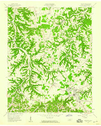
1958 Map of Lafayette
USGS Topo · Published 1959About this map
The town of Lafayette serves as the focal point for this Macon County survey, showing the community just as modern infrastructure began to weave through the traditional landscape. To the north and west, the terrain is defined by a dense network of hollows like Wildcat Hollow and Shoemake Hollow, where family-named cemeteries such as Lyles Cem and Cliburn Cem are tucked away. This era captures a specific cultural transition, evidenced by the presence of both an Orphanage and a Drive-in Theater near Maple Grove.
Find a feature on this map
61 named features on this map. Tap any name to fly to it.
Don’t see what you’re looking for? This feature index may not catch every label — zoom into the map to look around manually.
Map Details
Editions of this 1958 Lafayette Map
3 editions found
Other maps of this area

1931 · Lafayette
USGS Topo · 1:62,500

1931 · Red Boiling Springs
USGS Topo · 1:62,500

1932 · Carthage
USGS Topo · 1:62,500

1954 · Fountain Run
USGS Topo · 1:24,000

1954 · Petroleum
USGS Topo · 1:24,000

1954 · Holland
USGS Topo · 1:24,000

1956 · Corbin
USGS Topo · 1:250,000

1956 · Nashville
USGS Topo · 1:250,000

1958 · Corbin
USGS Topo · 1:250,000

1958 · Westmoreland
USGS Topo · 1:24,000