1950s Maps of Marion County, Tennessee
Explore 13 historic maps of Marion County from the 1950s. These maps offer a rare glimpse into what life looked like during the 1950s — showing old roads, neighborhoods, homes, and landmarks that have changed or disappeared over time.
Whether you're researching your family's past, planning a metal detecting trip, or studying how Marion County's landscape evolved across the 1950s, these high-resolution maps are a powerful tool for exploring the history of this region.
- Focus on a specific era: All maps on this page are from the 1950s, giving you a focused view of this time period.
- See what’s changed: Compare century-old streets, trails, and buildings to today's modern landscape using overlays and satellite layers.
- Research with precision: Use these maps for genealogy, historical research, land use analysis, or educational projects.
- View, download, or print: Maps are fully viewable online in high resolution, and can be downloaded or printed for your own records.
Start exploring Marion County's history through authentic maps from the 1950s. This is your window into the past.
Marion County, TN maps
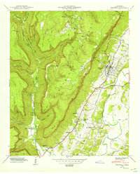
(13)- 1950 Map of Monteagle
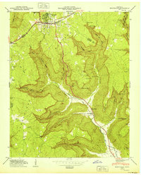 1950 Monteagle1950 Print · USGSMonteagle and the surrounding Cumberland Plateau are shown at mid-century as a network of plateau settlements and deep cove farms. Researchers can trace family history through numerous rural landmarks like Lappin Cem, St Johns Ch, and the Jumpoff Sch.3 unique versions available
 - 1950 Map of Orme
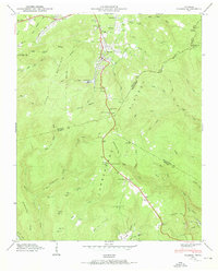
 1950 Orme1950 Print · USGSMarion County at mid-century reveals a landscape of isolated coves and high plateau settlements tucked into the Cumberland Mountains. Genealogists and hikers can trace old family sites like the Thomas Cem or locate the remote Orme Mountain School and Lous Chapel.
 - 1950 Map of Tracy City
 1950 Tracy City1950 Print · USGSThe industrial and social landscape of the Cumberland Plateau is revealed in this mid-century survey of the Grundy County highlands. Local historians can trace the influence of the N C & S T L railroad on settlements like Coalmont and locate family landmarks such as Bonnie Oak Cem and Nunley Sch.
 - 1950 Map of White City
 1950 White City1950 Print · USGSThe Cumberland Plateau in the late 1940s is captured here in intricate detail, showing a landscape of deep coves and ridge-top settlements. Genealogists can trace family locations like Sides Place or Lankford Town, and find landmarks like Foster Falls Sch.
 - 1950 Map of Whitwell
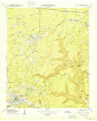
 1950 Whitwell1950 Print · USGSThe industrial and agricultural heart of Marion County is captured here in the mid-twentieth century as the Whitwell Mine overlooks the valley. Researchers can trace family sites at Ketner Mill, Victoria Sch, and the Mt Zion Cem.2 unique versions available
 - 1950 Map of Doran Cove
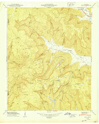
 1950 Doran Cove1950 Print · USGSJackson County, Alabama, is shown here as the post-war industrial era arrives along the Tennessee River. Researchers can trace family sites at Hackworth Cem, visit Coopers Mill, or locate the Widows Creek Steam Plant during its construction.2 unique versions available
 - 1950 Map of Palmer
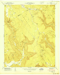
 1950 Palmer1950 Print · USGSThe Cumberland Plateau coal mining district comes into focus mid-century as rail lines and mines reached into the coves. Genealogists and researchers can locate family sites like Layne Cem, the Palmer Mine, and the Tatesville Sch.2 unique versions available
 - 1953 Map of Chattanooga
 1953 Chattanooga1953 Print · USGSSoutheast Tennessee in the early fifties shows a landscape reshaped by river management and rail power. Trace the rail lines of the Southern Ry through riverside towns or locate the preserved grounds of the Chickamauga and Chattanooga National Military Park.
 - 1955 Map of Rome
 1955 Rome1955 Print · USGSThe tri-state borderlands of Georgia, Alabama, and Tennessee appear in the mid-fifties as a landscape of ridge-and-valley industry and river navigation. Genealogists can trace family footprints near Chattanooga, the iron works of Gadsden, and textile towns like Trion or Summerville.
 - 1957 Map of Chattanooga, 1966 Print
 1957 Chattanooga1966 Print · USGSEast Tennessee in the mid-1960s shows a landscape of massive hydroelectric reservoirs and emerging industrial sites like the Atomic Energy Commission (Oak Ridge Area). Trace the rail networks of the Southern Ry through Chattanooga or locate family-named ridges across the Cumberland Plateau.3 unique versions available
 - 1958 Map of Chattanooga, 1959 Print
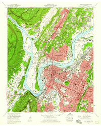 1958 Chattanooga1959 Print · USGSChattanooga and the Tennessee River valley are shown in the late fifties at a peak of industrial and suburban development. Genealogists and historians can trace family names at Sivley Cem, explore the massive Citico Yards, and locate landmarks like the Baylor Sch.3 unique versions available
 - 1958 Map of Rome, 1966 Print
 1958 Rome1966 Print · USGSNorthwest Georgia and neighboring Tennessee and Alabama are captured here in the late fifties, showcasing a landscape of high ridges and river valleys. Researchers can trace historic rail lines like the Seaboard Air Line RR and explore the bounds of Cloudland Canyon State Park or Fort Oglethorpe.3 unique versions available
 - 1959 Map of Chattanooga
 1959 Chattanooga1959 Print · USGSSoutheast Tennessee is shown here during a decade of industrial growth and hydroelectric development. Trace the regional rail networks of the Southern Ry and find landmark sites like Lookout Mountain, Fall Creek Falls State Park, and Chattanooga.
End of results
Showing maps 1-13 of 13
Top cities of Marion County
- South Pittsburg historical maps
- Jasper historical maps
- Whitwell historical maps
- Kimball historical maps
- Powells Crossroads historical maps
- New Hope historical maps
See more
Frequently asked questions
- What are the different types of historical maps available for Marion County?
- What is the oldest map of Marion County?
- Where can I purchase historical maps of Marion County for my home or office?
- Where can I download high-res historical maps of Marion County?
- Are there historical topographic maps available for Marion County?
- Is there historical aerial imagery available for Marion County?
- Where are historical maps of Marion County sourced from?