Old Maps of Marion County, Tennessee for Hiking & Exploration
Hike through history with 159 historic maps of Marion County. Explore old trails, ghost towns, and forgotten backroads — perfect for outdoor adventurers and local explorers.
- Rediscover forgotten places: Map out old mining camps, roads, and footpaths that no longer exist on modern maps.
- Layer with modern tools: Combine with LiDAR or satellite views to plan hikes through historical terrain.
- Made for exploration: Popular among hikers, overlanders, and local history lovers.
Use these maps to find adventure and explore the hidden past of Marion County.
Marion County, TN maps
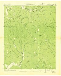
(159)- 1886 Map of Ringgold
 1886 Ringgold1886 Print · USGSNorthwest Georgia in the 1880s was a landscape of industrial river valleys and steep ridges defined by early rail lines. Local historians can trace family-named landmarks like Gilreath's Mill, the Trion Factory textile site, and the rural stop at Tap's Store.
 - 1886 Map of Stevenson
 1886 Stevenson1886 Print · USGSNortheast Alabama at the peak of the railroad era shows a landscape tied to the river and the rails. Genealogists can trace family landmarks like Coffey's Store or locate river crossings such as Caperton Ferry and Snodgrass Ferry.
 - 1888 Map of Chattanooga
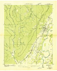
 1888 Chattanooga1888 Print · USGSSoutheast Tennessee in the late nineteenth century was a landscape of river ferries and mountain mining. Trace family roots and vanished landmarks near Chattanooga, from the Aetna Mines to historic river crossings like Harrison Ferry.
 - 1892 Map of Ringgold
 1892 Ringgold1892 Print · USGSNorth Georgia and the Tennessee border are mapped here in the late nineteenth century as the region transitioned into a post-war rail and tourism hub. Researchers can trace the early National Park boundaries, industrial Coal Mines, and vanished stops like High Point or Lisbon Sta..9 unique versions available
 - 1892 Map of Stevenson
 1892 Stevenson1892 Print · USGSNortheast Alabama and the Tennessee border in the 1890s reveal a landscape of mountain coves and vital river crossings. Genealogists and historians can trace rail junctions at Stevenson, river landings like Coffey's Ferry, and landmarks like Nickajack Cave.
 - 1893 Map of Chattanooga
 1893 Chattanooga1893 Print · USGSSoutheast Tennessee is shown here in the 1890s, when river ferries and coal mines defined the landscape around the booming hub of Chattanooga. Genealogists and researchers can trace family lands near Eldridge Landing, the Mc Nabb Mines, or old settlements like Ooltewah.9 unique versions available
 - 1895 Map of Stevenson
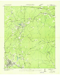
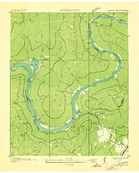
 1895 Stevenson1895 Print · USGSThe Tennessee River valley and surrounding plateaus were a hub of rail and river commerce at the close of the century. Genealogists can trace family crossings at Island Creek Ferry or locate old communities like Bellefonte, Stevenson, and Valley Head.6 unique versions available
 - 1895 Map of Sewanee
 1895 Sewanee1895 Print · USGSThe Cumberland Plateau and Sequatchie Valley come alive in the late nineteenth century, showing a landscape shaped by coal, iron, and the rails. Genealogists and historians can trace family-named coves and industrial sites like the Cowan Tunnel, Beersheba Springs, and the Stone Quarry.6 unique versions available
 - 1936 Map of Palmer
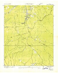 1936 Palmer1936 Print · USGSMid-1930s Grundy County comes alive through this look at the plateau's rail-and-coal industry. Trace the complex narrow gage routes serving the Clifty Mines or locate family roots near Tatesville and Griffith Sch.
 - 1936 Map of Shellmound
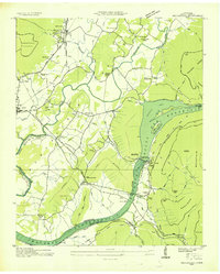
 1936 Shellmound1936 Print · USGSThe tristate borderlands of Georgia, Alabama, and Tennessee are captured here in the mid-1930s before the flooding of the Guntersville Reservoir. Genealogists can locate family landmarks like Stephens Cem, Burnett Chapel, and several local schools like Poplar Spring Sch.
 - 1936 Map of Daus
 1936 Daus1936 Print · USGSThe Sequatchie Valley was a bustling corridor of rail and river industry in the mid-1930s, caught between the Cumberland Plateau and Walden Ridge. Genealogists and historians can locate old schools and cemeteries like John Henry Chapel Sch, Stone Cem, and the community of Cartwright.
 - 1936 Map of Orme
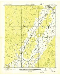
 1936 Orme1936 Print · USGSThe Cumberland Plateau mining economy and valley settlements are preserved in this mid-1930s survey of Marion County. Genealogists and industrial historians can trace the rail lines at Orme, the Battle Creek Mines, and community sites like Sweden Cove Sch.
 - 1936 Map of Bridgeport
 1936 Bridgeport1936 Print · USGSBridgeport and the Tennessee River valley are seen here in the mid-1930s, just as the proposed Guntersville Reservoir was set to reshape the riverbank. Genealogists and historians can trace family locations near Richard City, locate the Island Creek Ferry, and find early sites like Mc Daniel Chapel and Concord Sch.
 - 1936 Map of Whitwell
 1936 Whitwell1936 Print · USGSThe Sequatchie Valley and Cumberland Plateau are documented in the mid-1930s, showing a landscape shaped by coal and rail. Genealogists can locate family landmarks like Walker Cem, Red Hill Sch, and the historic Ketner Mill.
 - 1936 Map of Tracy City
 1936 Tracy City1936 Print · USGSThe industrial and social fabric of the Cumberland Plateau is detailed here in the mid-1930s. Genealogists and local historians can trace the rail networks of the St Louis and Chattanooga Railroad and locate community landmarks like Burkett Chapel and the Nyack Sch.
 - 1936 Map of Ketner Gap
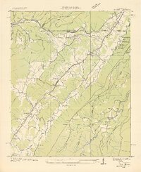
 1936 Ketner Gap1936 Print · USGSMarion and Sequatchie counties appear in the mid-1930s as a landscape of isolated coal mines and ridge-top gaps. Genealogists and historians can trace family locations through Grayson Cem, Sulphur Springs Sch, and the industrial sites at Barnes Mine.
 - 1936 Map of Monteagle
 1936 Monteagle1936 Print · USGSMonteagle and the surrounding Cumberland Plateau are captured here in the mid-1930s, showing the complex interaction between mountain travel and valley settlement. Researchers can trace historic schools and churches like Jumpoff Sch, St Johns Ch, and the high-altitude Monteagle Falls.
 - 1936 Map of Hooker
 1936 Hooker1936 Print · USGSNorthwest Georgia and neighboring Tennessee appear here in the mid-thirties, showing a landscape defined by mountain gaps and river valleys. Researchers can trace the path of Southern Railway through Morganville or locate family sites like Bethlehem Cem and Slygo Ch.
 - 1936 Map of White City
 1936 White City1936 Print · USGSMarion and Grundy Counties were still defined by remote plateau life and timber or mining interests in the mid-1930s. Genealogists can locate family homesites near White City, Lankford Town, or rural schools like Prior Sch and Foster Falls Sch.
 - 1936 Map of Wauhatchie
 1936 Wauhatchie1936 Print · USGSThe Tennessee River gorge comes alive in this mid-1930s survey of the Marion and Hamilton county line during the early TVA era. Genealogists can trace family landmarks like French Cem and Mc Nabb Cem, or locate industry at Aetna and several Mines (Abandoned).
 - 1936 Map of Sequatchie
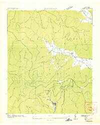
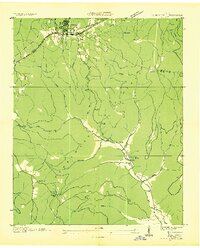
 1936 Sequatchie1936 Print · USGSMarion County is captured during its mid-1930s transformation as the TVA restructured the Tennessee River for hydroelectric power. Researchers can locate vanished landmarks like Rankin Ferry and the Marion County Home, or trace family roots at Old Union Cem and Wesley Chapel.
 - 1936 Map of Chattanooga
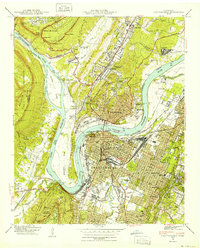
 1936 Chattanooga1936 Print · USGSChattanooga and the Tennessee River are shown here in the mid-thirties as the river valley underwent massive transformation. Trace the historic street grid and landmarks like the Incline Railway, National Cem, and Moccasin Bend.
 - 1936 Map of Doran Cove
 1936 Doran Cove1936 Print · USGSJackson County and the Tennessee River are captured here in the mid-1930s as the Tennessee Valley Authority planned the region's modernization. Researchers can locate family landmarks like the Rosenwald Sch, Widows Bar Lock and Dam, and Bonaventure Cem.
 - 1936 Map of South Pittsburg
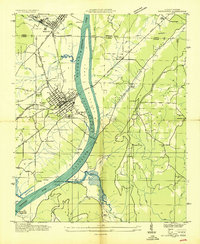
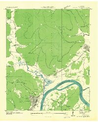 1936 South Pittsburg1936 Print · USGSMarion County is seen here during a pivotal era of transformation as the Tennessee Valley Authority prepared for new reservoirs. Genealogists and historians can trace family-named sites like Gilliam Cem or Raulstontown, alongside the river-based commerce of the South Pittsburg Ferry.
 - 1940 Map of Chattanooga
 1940 Chattanooga1940 Print · USGSChattanooga and the Tennessee River valley are captured here at the dawn of the 1940s, showcasing a bustling rail and river hub. Researchers can trace the legacy of Union Station, find family plots in National Cem, or locate the historic Cravens House on the slopes of Lookout Mountain.2 unique versions available
Showing maps 1-25 of 159
Top cities of Marion County
- South Pittsburg historical maps
- Jasper historical maps
- Whitwell historical maps
- Kimball historical maps
- Powells Crossroads historical maps
- New Hope historical maps
See more
Frequently asked questions
- What are the different types of historical maps available for Marion County?
- What is the oldest map of Marion County?
- Where can I purchase historical maps of Marion County for my home or office?
- Where can I download high-res historical maps of Marion County?
- Are there historical topographic maps available for Marion County?
- Is there historical aerial imagery available for Marion County?
- Where are historical maps of Marion County sourced from?