1930s Maps of Jasper, Tennessee
Explore 2 historic maps of Jasper from the 1930s. These maps offer a rare glimpse into what life looked like during the 1930s — showing old roads, neighborhoods, homes, and landmarks that have changed or disappeared over time.
Whether you're researching your family's past, planning a metal detecting trip, or studying how Jasper's landscape evolved across the 1930s, these high-resolution maps are a powerful tool for exploring the history of this region.
- Focus on a specific era: All maps on this page are from the 1930s, giving you a focused view of this time period.
- See what’s changed: Compare century-old streets, trails, and buildings to today's modern landscape using overlays and satellite layers.
- Research with precision: Use these maps for genealogy, historical research, land use analysis, or educational projects.
- View, download, or print: Maps are fully viewable online in high resolution, and can be downloaded or printed for your own records.
Start exploring Jasper's history through authentic maps from the 1930s. This is your window into the past.
Jasper, TN maps
(2)- 1936 Map of Sequatchie
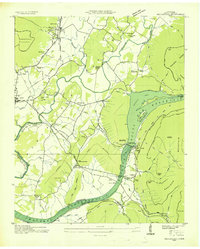 1936 Sequatchie1936 Print · USGSMarion County is captured during its mid-1930s transformation as the TVA restructured the Tennessee River for hydroelectric power. Researchers can locate vanished landmarks like Rankin Ferry and the Marion County Home, or trace family roots at Old Union Cem and Wesley Chapel.
 - 1936 Map of South Pittsburg
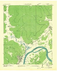 1936 South Pittsburg1936 Print · USGSMarion County is seen here during a pivotal era of transformation as the Tennessee Valley Authority prepared for new reservoirs. Genealogists and historians can trace family-named sites like Gilliam Cem or Raulstontown, alongside the river-based commerce of the South Pittsburg Ferry.
End of results
Showing maps 1-2 of 2
Top cities near Jasper
- Chattanooga historical maps
- South Pittsburg historical maps
- Bridgeport historical maps
- Trenton historical maps
- Stevenson historical maps
- Tracy City historical maps
See more
Top neighborhoods of Jasper
Frequently asked questions
- What are the different types of historical maps available for Jasper?
- What is the oldest map of Jasper?
- Where can I purchase historical maps of Jasper for my home or office?
- Where can I download high-res historical maps of Jasper?
- Are there historical topographic maps available for Jasper?
- Is there historical aerial imagery available for Jasper?
- Where are historical maps of Jasper sourced from?