1900-1909 Maps of Maury County, Tennessee
Explore 2 historic maps of Maury County from 1900-1909. These maps offer a rare glimpse into what life looked like during the 1900s — showing old roads, neighborhoods, homes, and landmarks that have changed or disappeared over time.
Whether you're researching your family's past, planning a metal detecting trip, or studying how Maury County's landscape evolved across the 1900s, these high-resolution maps are a powerful tool for exploring the history of this region.
- Focus on a specific era: All maps on this page are from the 1900s, giving you a focused view of this time period.
- See what’s changed: Compare century-old streets, trails, and buildings to today's modern landscape using overlays and satellite layers.
- Research with precision: Use these maps for genealogy, historical research, land use analysis, or educational projects.
- View, download, or print: Maps are fully viewable online in high resolution, and can be downloaded or printed for your own records.
Start exploring Maury County's history through authentic maps from the 1900s. This is your window into the past.
Maury County, TN maps
(2)- 1901 Map of Colombia
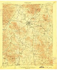
 1901 Colombia1901 Print · USGSMiddle Tennessee at the close of the century reveals a landscape shaped by river bends and a dense network of turnpikes. Genealogists can trace family roots through settlements like Santa Fe and Warner or locate landmarks such as the U.S. Arsenal and Zion Ch.3 unique versions available
 - 1909 Map of Franklin
 1909 Franklin1909 Print · USGSWilliamson County at the start of the twentieth century remains a landscape of historic pikes and rail-side villages. Genealogists can locate family homesteads near landmarks like Thompsons Station, Leipers Fork, and the Boiling Spring Academy.2 unique versions available
End of results
Showing maps 1-2 of 2
Top cities of Maury County
Frequently asked questions
- What are the different types of historical maps available for Maury County?
- What is the oldest map of Maury County?
- Where can I purchase historical maps of Maury County for my home or office?
- Where can I download high-res historical maps of Maury County?
- Are there historical topographic maps available for Maury County?
- Is there historical aerial imagery available for Maury County?
- Where are historical maps of Maury County sourced from?